
Make a donation
Gear up for your next adventure:
As an Amazon Associate, this site earns from qualifying purchases at no extra cost to you.
Pilar topographic map
Click on the map to display elevation.
Make a donation
Gear up for your next adventure:
As an Amazon Associate, this site earns from qualifying purchases at no extra cost to you.
About this map
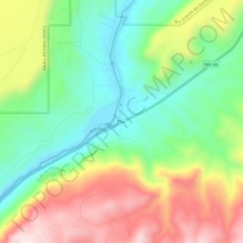
Name: Pilar topographic map, elevation, terrain.
Location: Pilar, Taos County, New Mexico, United States (36.24894 -105.80758 36.28894 -105.76758)
Average elevation: 6,670 ft
Minimum elevation: 5,984 ft
Maximum elevation: 7,671 ft
Taos County trails, hiking, mountain biking, running and outdoor activities
Make a donation
Gear up for your next adventure:
As an Amazon Associate, this site earns from qualifying purchases at no extra cost to you.
Other topographic maps
Click on a map to view its topography, its elevation and its terrain.
Taos Ski Valley
United States > New Mexico > Taos County
Taos Ski Valley is a village and alpine ski resort in the southwestern United States, located in Taos County, New Mexico. The population was 69 at the 2010 census. Until March 19, 2008, it was one of four ski resorts in America to prohibit snowboarding. The Kachina lift, constructed in 2014, serves one of the…
Average elevation: 10,850 ft