
Make a donation
Gear up for your next adventure:
As an Amazon Associate, this site earns from qualifying purchases at no extra cost to you.
Cabresto Lake topographic map
Click on the map to display elevation.
Make a donation
Gear up for your next adventure:
As an Amazon Associate, this site earns from qualifying purchases at no extra cost to you.
About this map
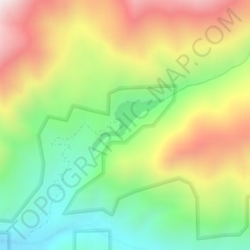
Name: Cabresto Lake topographic map, elevation, terrain.
Location: Cabresto Lake, Taos County, New Mexico, United States (36.74439 -105.50237 36.75019 -105.49261)
Average elevation: 9,623 ft
Minimum elevation: 8,356 ft
Maximum elevation: 11,263 ft
Taos County trails, hiking, mountain biking, running and outdoor activities
Make a donation
Gear up for your next adventure:
As an Amazon Associate, this site earns from qualifying purchases at no extra cost to you.
Other topographic maps
Click on a map to view its topography, its elevation and its terrain.
Make a donation
Gear up for your next adventure:
As an Amazon Associate, this site earns from qualifying purchases at no extra cost to you.
Tres Piedras
United States > New Mexico > Taos County
Tres Piedras is located approximately 30 miles northwest of Taos, and west of the Rio Grande on U.S. Route 64. At approximately 8,000 feet (2,400 m) in altitude, it is located within the southern portion of the San Juan Range of the Rocky Mountains. Tres Piedras is on the western edge of a sagebrush plain,…
Average elevation: 8,123 ft
Sipapu
United States > New Mexico > Taos County
Sipapu Ski & Summer Resort, also known simply as Sipapu, is a moderately sized ski resort in Taos County, New Mexico. It is home to New Mexico's longest ski season, from November to April. The peak elevation is 9,255 ft (2,821 m). There are 41 trails and 6 lifts. Other facilities include 4 terrain parks, golf,…
Average elevation: 9,035 ft
Make a donation
Gear up for your next adventure:
As an Amazon Associate, this site earns from qualifying purchases at no extra cost to you.
Make a donation
Gear up for your next adventure:
As an Amazon Associate, this site earns from qualifying purchases at no extra cost to you.
Rio Grande Rift Historical Marker
United States > New Mexico > Taos County
Average elevation: 7,087 ft