
Make a donation
Gear up for your next adventure:
As an Amazon Associate, this site earns from qualifying purchases at no extra cost to you.
Marul topographic map
Click on the map to display elevation.
Make a donation
Gear up for your next adventure:
As an Amazon Associate, this site earns from qualifying purchases at no extra cost to you.
About this map
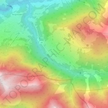
Name: Marul topographic map, elevation, terrain.
Location: Marul, Raggal, Bezirk Bludenz, Vorarlberg, 6741, Österreich (47.18148 9.84295 47.22148 9.88295)
Average elevation: 4,206 ft
Minimum elevation: 2,264 ft
Maximum elevation: 6,424 ft
Make a donation
Gear up for your next adventure:
As an Amazon Associate, this site earns from qualifying purchases at no extra cost to you.
Other topographic maps
Click on a map to view its topography, its elevation and its terrain.
Montafon
Österreich > Vorarlberg > Bezirk Bludenz > Schruns
Das Montafon (anhören) ist ein 39 Kilometer langes Tal in Vorarlberg (Österreich), das von der Bielerhöhe bis Bludenz reicht und von der Ill durchflossen wird. Das Tal wird im Norden von der Verwallgruppe und im Süden vom Rätikon und der Silvretta begrenzt. Die höchste Erhebung in der Umgebung ist der…
Average elevation: 5,138 ft
Nenzing
Österreich > Vorarlberg > Bezirk Bludenz
Nenzing liegt im westlichsten Bundesland Österreichs, Vorarlberg, im Bezirk Bludenz auf 533 Metern Höhe. Mit einer Fläche von 110,31 km² ist Nenzing die viertgrößte Gemeinde Vorarlbergs. 49,3 % der Fläche sind bewaldet, 21,1 % der Fläche Alpen. Mit 2859 m ü. A. ist der Panüler der höchste Berg der…
Average elevation: 4,603 ft
Make a donation
Gear up for your next adventure:
As an Amazon Associate, this site earns from qualifying purchases at no extra cost to you.
Raggal
Österreich > Vorarlberg > Bezirk Bludenz
Die Gemeinde liegt im westlichsten Bundesland Österreichs, Vorarlberg, im Bezirk Bludenz auf durchschnittlich 1015 m ü. A. Höhe. Das gesamte Gemeindegebiet liegt im UNESCO-Biosphärenpark Großes Walsertal. 47 % der Fläche sind bewaldet, 19 % der Fläche Alpen. Es gibt ca. 50 landwirtschaftliche Betriebe.…
Average elevation: 3,675 ft
Schruns
Österreich > Vorarlberg > Bezirk Bludenz
Schruns liegt in Vorarlberg, dem westlichsten Bundesland Österreichs, im Bezirk Bludenz auf 690 Metern Höhe im Alpental Montafon an der Litz, einem Nebenfluss der Ill. Von Schruns aus erstreckt sich ein Seitental des Montafons namens Silbertal. Zu Schruns gehört das Hochjoch-Bergmassiv der Verwallgruppe,…
Average elevation: 4,511 ft
Bürserberg
Österreich > Vorarlberg > Bezirk Bludenz
Die Berggemeinde Bürserberg liegt im westlichsten Bundesland Österreichs, Vorarlberg, im Bezirk Bludenz auf 871 Metern Höhe. Sie befindet sich am Eingang des Brandnertales – rund 5 km von Bludenz entfernt und ist eine in mehreren Terrassen gegliederte Hangsiedlung.
Average elevation: 4,157 ft
Gemeinde Tschagguns
Österreich > Vorarlberg > Bezirk Bludenz
Tschagguns liegt im westlichsten Bundesland Österreichs, Vorarlberg, im Bezirk Bludenz. Das Siedlungsgebiet der Gemeinde erstreckt sich über eine Höhe von 650 bis 1.200 Metern Höhe.
Average elevation: 5,335 ft
Make a donation
Gear up for your next adventure:
As an Amazon Associate, this site earns from qualifying purchases at no extra cost to you.
Gemeinde Ludesch
Österreich > Vorarlberg > Bezirk Bludenz
Ludesch liegt am südöstlichen Ufer der Lutz, noch im Walgau, aber am Eingang zum Großen Walsertal. Das Ortszentrum befindet sich auf 555 m ü. A. Im Norden und Nordwesten wird das Gemeindegebiet von der Lutz begrenzt, im Süden von der Ill, im Südosten folgt die Gemeindegrenze dem Höhenrücken von der…
Average elevation: 2,697 ft
Gemeinde Thüringen
Österreich > Vorarlberg > Bezirk Bludenz
Thüringen liegt im westlichsten Bundesland Österreichs, Vorarlberg, im Bezirk Bludenz. Die Grenze im Süden bildet die Lutz, die in einer Höhe 570 Metern fließt. Nach Nordwesten steigt das Land zu bewaldeten Höhen von 500 Meter an. Die Bezirkshauptstadt Bludenz liegt etwa 9 Kilometer südöstlich.
Average elevation: 2,051 ft
Gemeinde Blons
Österreich > Vorarlberg > Bezirk Bludenz
Blons liegt auf der Nordseite des Großen Walsertals. Die Grenze im Süden bildet die Lutz, im Osten der Ladritschbach, im Westen der Rüffibach und der Höhenrücken zwischen Rüffibach und Mühletobel. Von der Lutz, deren tiefster Punkt in der Gemeinde etwa 700 Meter hoch liegt, steigt das Land nach Norden…
Average elevation: 4,337 ft
Gemeinde Vandans
Österreich > Vorarlberg > Bezirk Bludenz
Vandans liegt im Montafon auf 648 Metern Höhe. 26,2 Prozent der Fläche sind bewaldet und 34 Prozent liegen im Gebiet der Alpen.
Average elevation: 5,400 ft
Make a donation
Gear up for your next adventure:
As an Amazon Associate, this site earns from qualifying purchases at no extra cost to you.
Gaschurn
Österreich > Vorarlberg > Bezirk Bludenz
Der Ortskern von Gaschurn Dorf liegt 979 m ü. A. im Montafon zwischen Gortipohl und dem zur Gemeinde Gaschurn gehörigen Ort Partenen, wobei sich der Höhenbereich auf bis 3312 m ü. A. (Piz Buin) erstreckt. Der größte Ort im Gemeindegebiet ist Gaschurn Dorf. 12,7 Prozent der Gemeindefläche sind bewaldet,…
Average elevation: 6,893 ft
Bludenz
Österreich > Vorarlberg > Bezirk Bludenz
Der Stadtkern von Bludenz liegt auf etwa 570 Meter Höhe am südwestlichen Fuß des Lechquellengebirges, terrassenförmig über dem Talboden der Ill und auf einem Teil des Schuttfächers des Galgentobelbaches angelegt. Die offizielle Höhenangabe für Bludenz von 588 m bezieht sich auf die Lage der etwas…
Average elevation: 3,291 ft
Silbertal
Österreich > Vorarlberg > Bezirk Bludenz
Der Ort Silbertal ist eine Streusiedlung und liegt im westlichsten Bundesland Österreichs, Vorarlberg, im Bezirk Bludenz auf 889 m ü. A. Höhe im Silbertal in der Verwallgruppe. Sein Name entstand infolge des früher dort betriebenen Kupfer- und Silberbergbaus.
Average elevation: 5,007 ft
Make a donation
Gear up for your next adventure:
As an Amazon Associate, this site earns from qualifying purchases at no extra cost to you.
Sankt Gallenkirch
Österreich > Vorarlberg > Bezirk Bludenz
Der Ort St. Gallenkirch liegt auf 878 Metern Höhe. Hauptfluss ist die Ill, das Gemeindegebiet umfasst auch das Einzugsgebiet des Suggadinbachs. Im Westen steigt das Gemeindegebiet zum Rätikon an. Die höchsten Gipfel sind Gargeller Madrisa (2770 m), Rotbühelspitze (2835 m) und Isentällispitz (2872 m). Im…
Average elevation: 6,138 ft
Dalaas
Österreich > Vorarlberg > Bezirk Bludenz
Das Gebiet von Dalaas wird durch das Klostertal gekennzeichnet, das von Ost nach West von der Alfenz (angebunden an das Flusssystem des Rheins) durchflossen und an ihr entlang durch die Arlbergbahn und die Arlberg Schnellstraße (S16/E60) durchquert wird. Im Norden des Dalaaser Gebiets findet sich das…
Average elevation: 5,515 ft
Make a donation
Gear up for your next adventure:
As an Amazon Associate, this site earns from qualifying purchases at no extra cost to you.
Lechquellengebirge
Österreich > Vorarlberg > Bezirk Bludenz
Weitere bekannte Gipfel des Lechquellengebirges, geordnet nach ihrer Höhe.
Average elevation: 5,144 ft
Verwallgruppe
Österreich > Vorarlberg > Bezirk Bludenz
Das Verwall ist ein für den durchschnittlichen Bergwanderer und Bergsteiger hervorragend geeignetes Gebirge. Im Gegensatz zur benachbarten Silvretta ist die Verwallgruppe nur gering vergletschert. Ein Netz von Höhenwegen erlaubt mehrtägige Touren von Hütte zu Hütte. Mehrere Gipfel, die alle in Tirol…
Average elevation: 6,421 ft
Silvrettagruppe
Österreich > Vorarlberg > Bezirk Bludenz
Die Silvretta ist eine Gebirgsgruppe in den zentralen Ostalpen. Anteil haben Österreich mit den Bundesländern Tirol und Vorarlberg und die Schweiz mit dem Kanton Graubünden. Auf dem Gipfel der Dreiländerspitze stoßen die Gebiete von Tirol, Vorarlberg und Graubünden zusammen. In der Silvretta liegen viele…
Average elevation: 7,126 ft
Alfenz
Österreich > Vorarlberg > Bezirk Bludenz
Die Alfenz entsteht bei Stuben auf einer Höhe von 1386,3 m ü. A. aus dem Zusammenfluss von Flexenbach und Rauzbach. Auf einer Länge von ca. 26 km fließt sie in westlicher Richtung von Stuben nach Bludenz und mündet schließlich 3,5 km vor der Stadt auf einer Höhe von 574,44 m ü. A. von rechts in die Ill.
Average elevation: 5,400 ft
Make a donation
Gear up for your next adventure:
As an Amazon Associate, this site earns from qualifying purchases at no extra cost to you.
Silvretta-Stausee
Österreich > Vorarlberg > Bezirk Bludenz > Gaschurn
Der 1,31 km² große Stausee (Oberfläche bei Stauziel) liegt knapp unterhalb der Bielerhöhe (2037 m ü. A.) auf einer Seehöhe von 2030 m in einer Senke der Silvretta, dem ehemaligen Ochsenboden. Über den östlichen Staudamm verläuft die Landesgrenze zwischen Tirol und Vorarlberg. Das Klostertal und das…
Average elevation: 7,146 ft
Lünersee
Österreich > Vorarlberg > Bezirk Bludenz > Vandans
Sein Wasserspiegel liegt bei Vollstau auf einer Höhe von 1970 m ü. A. am Fuße des Seekopfs und der Schesaplana. Nachdem das Land Vorarlberg bereits 1920 mit Abdichtungsarbeiten am Seegrund begonnen hatte, vergrößerte die Vorarlberger Illwerke AG das Speichervolumen des Sees 1958 mit einer Staumauer.
Average elevation: 6,909 ft
Seewaldsee
Österreich > Vorarlberg > Bezirk Bludenz > Fontanella > Garlitt
Das knapp 1,2 Hektar große Stillgewässer liegt am Südwesthang der Blasenka, 1,4 Kilometer östlich der Ortsmitte von Fontanella auf einer Höhe von 1132 m ü. A. Nördlich des Sees liegt die namensgebende Rotte Seewald, die wie auch der See selbst Teil der Gemeinde Fontanella ist.
Average elevation: 3,875 ft
Ochsental
Österreich > Vorarlberg > Bezirk Bludenz > Gaschurn
Am südlichen Ende des Silvretta-Stausees zweigt das durch den Klostertaler Bach gebildete Klostertal südwestlich vom Ochsental ab. Der nördliche Teil des Ochsentals bei der Bielerhöhe ist durch den Silvretta-Stausee die meiste Zeit des Jahres komplett mit Wasser bedeckt. Die ursprünglich ebenfalls im…
Average elevation: 8,058 ft
Make a donation
Gear up for your next adventure:
As an Amazon Associate, this site earns from qualifying purchases at no extra cost to you.
Bludenz
Österreich > Vorarlberg > Bezirk Bludenz
Der Stadtkern von Bludenz liegt auf etwa 570 Meter Höhe am südwestlichen Fuß des Lechquellengebirges, terrassenförmig über dem Talboden der Ill und auf einem Teil des Schuttfächers des Galgentobelbaches angelegt. Die offizielle Höhenangabe für Bludenz von 588 m bezieht sich auf die Lage der etwas…
Average elevation: 3,291 ft
Schruns
Österreich > Vorarlberg > Bezirk Bludenz
Schruns liegt in Vorarlberg, dem westlichsten Bundesland Österreichs, im Bezirk Bludenz auf 690 Metern Höhe im Alpental Montafon an der Litz, einem Nebenfluss der Ill. Von Schruns aus erstreckt sich ein Seitental des Montafons namens Silbertal. Zu Schruns gehört das Hochjoch-Bergmassiv der Verwallgruppe,…
Average elevation: 4,511 ft
Montafon
Österreich > Vorarlberg > Bezirk Bludenz > Schruns
Das Montafon ( Anhören?/i) ist ein 39 Kilometer langes Tal in Vorarlberg (Österreich), das von der Bielerhöhe bis Bludenz reicht und von der Ill durchflossen wird. Das Tal wird im Norden von der Verwallgruppe und im Süden vom Rätikon und der Silvretta begrenzt. Die höchste Erhebung in der Umgebung ist…
Average elevation: 5,138 ft
Make a donation
Gear up for your next adventure:
As an Amazon Associate, this site earns from qualifying purchases at no extra cost to you.
Brand
Österreich > Vorarlberg > Bezirk Bludenz
Brand liegt im Brandnertal, das zum österreichischen Rätikon gehört, auf 1.037 Metern Höhe an der Alvier. Der Ort ist im Westen, Süden und Osten von den Gipfeln des Rätikon umgeben. Die markantesten Gipfel im Westen sind Fundelkopf (2401 m), Oberzalimkopf (2340 m) und Panüeler Kopf (2859 m). Im Süden…
Average elevation: 5,958 ft
Bürs
Österreich > Vorarlberg > Bezirk Bludenz
Bürs ist eine Gemeinde mit 3447 Einwohnern (Stand 1. Jänner 2025) auf 570 Metern Höhe und gehört zum Bezirk Bludenz in Vorarlberg.
Average elevation: 3,973 ft
Make a donation
Gear up for your next adventure:
As an Amazon Associate, this site earns from qualifying purchases at no extra cost to you.
St. Gallenkirch
Österreich > Vorarlberg > Bezirk Bludenz
Der Ort St. Gallenkirch liegt auf 878 Metern Höhe. Hauptfluss ist die Ill, das Gemeindegebiet umfasst auch das Einzugsgebiet des Suggadinbachs. Im Westen steigt das Gemeindegebiet zum Rätikon an. Die höchsten Gipfel sind Gargeller Madrisa (2770 m), Rotbühelspitze (2835 m) und Isentällispitz (2872 m). Im…
Average elevation: 6,138 ft
Vandans
Österreich > Vorarlberg > Bezirk Bludenz
Vandans liegt im Montafon auf 648 Metern Höhe. 26,2 Prozent der Fläche sind bewaldet und 34 Prozent liegen im Gebiet der Alpen.
Average elevation: 4,938 ft
Gaschurn
Österreich > Vorarlberg > Bezirk Bludenz
Der Ortskern von Gaschurn Dorf liegt 979 m ü. A. im Montafon zwischen Gortipohl und dem zur Gemeinde Gaschurn gehörigen Ort Partenen, wobei sich der Höhenbereich auf bis 3312 m ü. A. (Piz Buin) erstreckt. Der größte Ort im Gemeindegebiet ist Gaschurn Dorf. 12,7 Prozent der Gemeindefläche sind bewaldet,…
Average elevation: 6,893 ft
Bürserberg
Österreich > Vorarlberg > Bezirk Bludenz
Die Berggemeinde Bürserberg liegt im westlichsten Bundesland Österreichs, Vorarlberg, im Bezirk Bludenz auf 871 Metern Höhe. Sie befindet sich am Eingang des Brandnertales – rund 5 km von Bludenz entfernt und ist eine in mehreren Terrassen gegliederte Hangsiedlung.
Average elevation: 3,547 ft
Make a donation
Gear up for your next adventure:
As an Amazon Associate, this site earns from qualifying purchases at no extra cost to you.
Silbertal
Österreich > Vorarlberg > Bezirk Bludenz
Der Ort Silbertal ist eine Streusiedlung und liegt im westlichsten Bundesland Österreichs, Vorarlberg, im Bezirk Bludenz auf 889 m ü. A. Höhe im Silbertal in der Verwallgruppe. Sein Name entstand infolge des früher dort betriebenen Kupfer- und Silberbergbaus.
Average elevation: 5,007 ft
Ludesch
Österreich > Vorarlberg > Bezirk Bludenz
Ludesch liegt am südöstlichen Ufer der Lutz, noch im Walgau, aber am Eingang zum Großen Walsertal. Das Ortszentrum befindet sich auf 555 m ü. A. Im Norden und Nordwesten wird das Gemeindegebiet von der Lutz begrenzt, im Süden von der Ill, im Südosten folgt die Gemeindegrenze dem Höhenrücken von der…
Average elevation: 2,349 ft
Dalaas
Österreich > Vorarlberg > Bezirk Bludenz
Das Gebiet von Dalaas wird durch das Klostertal gekennzeichnet, das von Ost nach West von der Alfenz (angebunden an das Flusssystem des Rheins) durchflossen und an ihr entlang durch die Arlbergbahn und die Arlberg Schnellstraße (S16/E60) durchquert wird. Im Norden des Dalaaser Gebiets findet sich das…
Average elevation: 5,846 ft
Silbertal
Österreich > Vorarlberg > Bezirk Bludenz
Der Ort Silbertal ist eine Streusiedlung und liegt im westlichsten Bundesland Österreichs, Vorarlberg, im Bezirk Bludenz auf 889 m ü. A. Höhe im Silbertal in der Verwallgruppe. Sein Name entstand infolge des früher dort betriebenen Kupfer- und Silberbergbaus.
Average elevation: 5,912 ft
Make a donation
Gear up for your next adventure:
As an Amazon Associate, this site earns from qualifying purchases at no extra cost to you.
Tschagguns
Österreich > Vorarlberg > Bezirk Bludenz
Tschagguns liegt im westlichsten Bundesland Österreichs, Vorarlberg, im Bezirk Bludenz. Das Siedlungsgebiet der Gemeinde erstreckt sich über eine Höhe von 650 bis 1.200 Metern Höhe.
Average elevation: 5,052 ft
Raggal
Österreich > Vorarlberg > Bezirk Bludenz
Die Gemeinde liegt im westlichsten Bundesland Österreichs, Vorarlberg, im Bezirk Bludenz auf durchschnittlich 1015 m ü. A. Höhe. Das gesamte Gemeindegebiet liegt im UNESCO-Biosphärenpark Großes Walsertal. 47 % der Fläche sind bewaldet, 19 % der Fläche Alpen. Es gibt ca. 50 landwirtschaftliche Betriebe.…
Average elevation: 3,675 ft
Dalaas
Österreich > Vorarlberg > Bezirk Bludenz
Das Gebiet von Dalaas wird durch das Klostertal gekennzeichnet, das von Ost nach West von der Alfenz (angebunden an das Flusssystem des Rheins) durchflossen und an ihr entlang durch die Arlbergbahn und die Arlberg Schnellstraße (S16/E60) durchquert wird. Im Norden des Dalaaser Gebiets findet sich das…
Average elevation: 5,515 ft
Klösterle
Österreich > Vorarlberg > Bezirk Bludenz
Am 11. Juli 2010 wurde ein Großteil des Ortskerns infolges eines heftigen Gewitters und eines Murgangs aus dem Wäldletobel überflutet. 30000 m³ angeschwemmtes Geschiebe lagerten sich im Ort und nahe der Mündung des Tobels in die Alfenz ab und behinderten den Abfluss der Wassermassen. Etwa 30 Gebäude…
Average elevation: 6,237 ft
Make a donation
Gear up for your next adventure:
As an Amazon Associate, this site earns from qualifying purchases at no extra cost to you.
Lechquellengebirge
Österreich > Vorarlberg > Bezirk Bludenz
Weitere bekannte Gipfel des Lechquellengebirges, geordnet nach ihrer Höhe.
Average elevation: 5,144 ft
Nenzing
Österreich > Vorarlberg > Bezirk Bludenz
Nenzing liegt im westlichsten Bundesland Österreichs, Vorarlberg, im Bezirk Bludenz auf 533 Metern Höhe. Mit einer Fläche von 110,31 km² ist Nenzing die viertgrößte Gemeinde Vorarlbergs. 49,3 % der Fläche sind bewaldet, 21,1 % der Fläche Alpen. Mit 2859 m ü. A. ist der Panüler der höchste Berg der…
Average elevation: 4,669 ft
Tschagguns
Österreich > Vorarlberg > Bezirk Bludenz
Tschagguns liegt im westlichsten Bundesland Österreichs, Vorarlberg, im Bezirk Bludenz. Das Siedlungsgebiet der Gemeinde erstreckt sich über eine Höhe von 650 bis 1.200 Metern Höhe.
Average elevation: 5,052 ft
Bürserberg
Österreich > Vorarlberg > Bezirk Bludenz
Die Berggemeinde Bürserberg liegt im westlichsten Bundesland Österreichs, Vorarlberg, im Bezirk Bludenz auf 871 Metern Höhe. Sie befindet sich am Eingang des Brandnertales – rund 5 km von Bludenz entfernt und ist eine in mehreren Terrassen gegliederte Hangsiedlung.
Average elevation: 3,547 ft
Make a donation
Gear up for your next adventure:
As an Amazon Associate, this site earns from qualifying purchases at no extra cost to you.
Gaschurn
Österreich > Vorarlberg > Bezirk Bludenz
Der Ortskern von Gaschurn Dorf liegt 979 m ü. A. im Montafon zwischen Gortipohl und dem zur Gemeinde Gaschurn gehörigen Ort Partenen, wobei sich der Höhenbereich auf bis 3312 m ü. A. (Piz Buin) erstreckt. Der größte Ort im Gemeindegebiet ist Gaschurn Dorf. 12,7 Prozent der Gemeindefläche sind bewaldet,…
Average elevation: 6,965 ft
Ochsental
Österreich > Vorarlberg > Bezirk Bludenz > Gaschurn
Am südlichen Ende des Silvretta-Stausees zweigt das durch den Klostertaler Bach gebildete Klostertal südwestlich vom Ochsental ab. Der nördliche Teil des Ochsentals bei der Bielerhöhe ist durch den Silvretta-Stausee die meiste Zeit des Jahres komplett mit Wasser bedeckt. Die ursprünglich ebenfalls im…
Average elevation: 8,058 ft
Silvrettagruppe
Österreich > Vorarlberg > Bezirk Bludenz
Die Silvretta ist eine Gebirgsgruppe in den zentralen Ostalpen. Anteil haben Österreich mit den Bundesländern Tirol und Vorarlberg und die Schweiz mit dem Kanton Graubünden. Auf dem Gipfel der Dreiländerspitze stoßen die Gebiete von Tirol, Vorarlberg und Graubünden zusammen. In der Silvretta liegen viele…
Average elevation: 7,126 ft
Make a donation
Gear up for your next adventure:
As an Amazon Associate, this site earns from qualifying purchases at no extra cost to you.