
Make a donation
Gear up for your next adventure:
As an Amazon Associate, this site earns from qualifying purchases at no extra cost to you.
Willow River topographic map
Click on the map to display elevation.
Make a donation
Gear up for your next adventure:
As an Amazon Associate, this site earns from qualifying purchases at no extra cost to you.
About this map
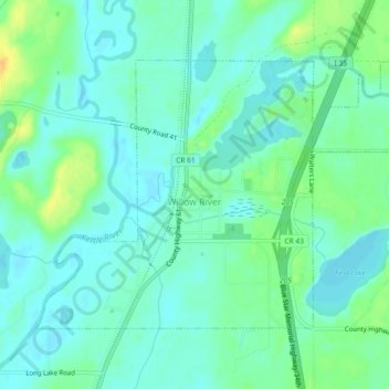
Name: Willow River topographic map, elevation, terrain.
Location: Willow River, Pine County, Minnesota, United States (46.30986 -92.85697 46.33168 -92.81127)
Average elevation: 1,047 ft
Minimum elevation: 1,017 ft
Maximum elevation: 1,115 ft
Pine County trails, hiking, mountain biking, running and outdoor activities
Make a donation
Gear up for your next adventure:
As an Amazon Associate, this site earns from qualifying purchases at no extra cost to you.
Other topographic maps
Click on a map to view its topography, its elevation and its terrain.
Devils Lake
United States > Minnesota > Pine County > Pine City > Pine Terrace Mobile Home Park
Average elevation: 968 ft
Chengwatana State Forest
United States > Minnesota > Pine County > Rock Creek
Average elevation: 925 ft
Make a donation
Gear up for your next adventure:
As an Amazon Associate, this site earns from qualifying purchases at no extra cost to you.