
Datong topographic map
Click on the map to display elevation.
Datong
Datong is a prefecture-level city in northern Shanxi Province in the People's Republic of China. It is located in the Datong Basin at an elevation of 1,040 metres (3,410 ft) and borders Inner Mongolia to the north and west and Hebei to the east. As of the 2020 census, it had a population of 3,105,591 of whom 1,790,452 lived in the built-up (or metro) area made of the 2 out 4 urban districts of Pingcheng and Yungang as Yunzhou and Xinrong are not conurbated yet.
About this map
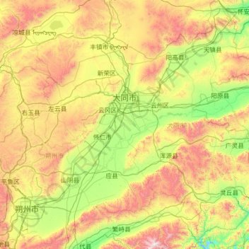
Name: Datong topographic map, elevation, terrain.
Location: Datong, Shanxi, China (39.04845 112.57067 40.74496 114.56551)
Average elevation: 4,393 ft
Minimum elevation: 2,264 ft
Maximum elevation: 9,938 ft
Other topographic maps
Click on a map to view its topography, its elevation and its terrain.
Changzhi
China > Shanxi > Changzhi > Yingxiongnanlu Subdistrict
Changzhi is located in southeastern Shanxi province, along the southern section of the Taihang Mountains. The majority of the city's area is mountainous, and much of the remaining geography is hilly in nature. The average elevation in the city is approximately 1,000 metres (3,300 ft) above sea level, with…
Average elevation: 3,235 ft
Huozhou
China > Shanxi > Huozhou City > Beihuanlu Subdistrict
The city's altitude ranges from 516 to 2,504.3 m (1,693 to 8,216 ft) in height. The Fen River runs through the city from north to south.
Average elevation: 2,979 ft