
Yanhu topographic map
Click on the map to display elevation.
About this map
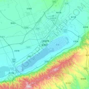
Name: Yanhu topographic map, elevation, terrain.
Location: Yanhu, Yanhu District, Yuncheng, Shanxi, 044031, China (34.85383 110.83728 35.17383 111.15728)
Average elevation: 1,614 ft
Minimum elevation: 1,040 ft
Maximum elevation: 4,386 ft
Other topographic maps
Click on a map to view its topography, its elevation and its terrain.
Changzhi City
Changzhi is located in southeastern Shanxi province, along the southern section of the Taihang Mountains. The majority of the city's area is mountainous, and much of the remaining geography is hilly in nature. The average elevation in the city is approximately 1,000 metres (3,300 ft) above sea level, with…
Average elevation: 3,461 ft
Youyu County
Elevations are generally higher in the south of the county, in which flows the Cangtou River (苍头河); Youyu reaches a north-south extent of 67.7 km (42.1 mi) and east-west width of 45.7 km (28.4 mi). The Great Wall demarcates the northwestern border with Inner Mongolia's Liangcheng and Horinger counties;…
Average elevation: 4,875 ft
Taiyuan
Taiyuan experiences a cold semi-arid climate (Köppen climate classification BSk). Taiyuan has a temperate monsoon climate.Spring is dry, with occasional dust storms, followed by early summer heat waves. Summer tends to be warm to hot with most of the year's rainfall concentrated in July and August. Winter is…
Average elevation: 3,921 ft
Fushan County
Fushan County is located in the south of Shanxi Province, bordering Yaodu District and Xiangfen County to the west, Yicheng County to the south, Anze County to the east, Gu County to the north, and Qinshui County to the southeast. The county varies in altitude from 650 meters in height to 1,511.8 meters in…
Average elevation: 3,143 ft
Taiyuan City
Taiyuan experiences a cold semi-arid climate (Köppen climate classification BSk). Taiyuan has a temperate monsoon climate.Spring is dry, with occasional dust storms, followed by early summer heat waves. Summer tends to be warm to hot with most of the year's rainfall concentrated in July and August. Winter is…
Average elevation: 3,921 ft
Datong
Datong is a prefecture-level city in northern Shanxi Province in the People's Republic of China. It is located in the Datong Basin at an elevation of 1,040 metres (3,410 ft) and borders Inner Mongolia to the north and west and Hebei to the east. As of the 2020 census, it had a population of 3,105,591 of whom…
Average elevation: 4,393 ft