
Make a donation
Gear up for your next adventure:
As an Amazon Associate, this site earns from qualifying purchases at no extra cost to you.
Pohnpei topographic map
Click on the map to display elevation.
Make a donation
Gear up for your next adventure:
As an Amazon Associate, this site earns from qualifying purchases at no extra cost to you.
About this map
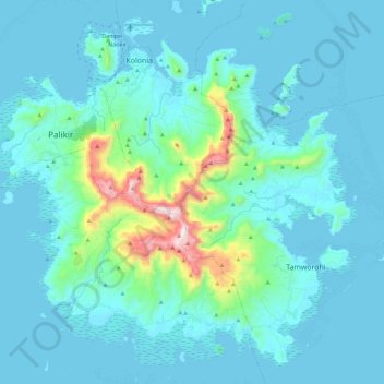
Name: Pohnpei topographic map, elevation, terrain.
Average elevation: 285 ft
Minimum elevation: -3 ft
Maximum elevation: 2,566 ft
Make a donation
Gear up for your next adventure:
As an Amazon Associate, this site earns from qualifying purchases at no extra cost to you.
Other topographic maps
Click on a map to view its topography, its elevation and its terrain.
Palikir
Federated States of Micronesia > Pohnpei > Sokehs
Palikir is located in the northwestern center of Pohnpei Island (formerly known as Ponape). Geologically the island terrain consists of high mountains to low coral atolls. It is the largest, highest, wettest and most scenic island of the Federated States of Micronesia. Palikir is 8 kilometers (5 miles)…
Average elevation: 387 ft
Make a donation
Gear up for your next adventure:
As an Amazon Associate, this site earns from qualifying purchases at no extra cost to you.