Geolocate

Silver Creek topographic map

Click on the map to display elevation.

About this map

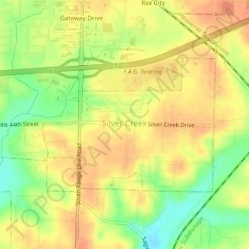
Name: Silver Creek topographic map, elevation, terrain.

Location: Silver Creek, Newton County, Missouri, United States (37.03315 -94.47913 37.04765 -94.46038)

Average elevation: 1,033 ft

Minimum elevation: 945 ft

Maximum elevation: 1,086 ft

Newton County trails, hiking, mountain biking, running and outdoor activities

Other topographic maps

Click on a map to view its topography, its elevation and its terrain.

Hornet

United States > Missouri > Newton County

Average elevation: 1,096 ft

Gateway Drive

United States > Missouri > Newton County > Joplin

Average elevation: 1,047 ft

Westview

United States > Missouri > Newton County

Average elevation: 1,119 ft

Ritchey

United States > Missouri > Newton County > Ritchey

Average elevation: 1,132 ft

Big Spring Park

United States > Missouri > Newton County > Neosho

Average elevation: 1,093 ft

Gear up for your next adventure:

🚗GPS Dash Cams - Record your scenic drives through mountain passes and canyons
🍳Camping Cook Set - Complete cookware for outdoor meals
Solar GPS Watches - Advanced multisport watches with built-in topographic maps
🧭GPS Watch Accessories - Bands and chargers for GPS watches
🦟Ultrasonic Repellers - Create a bug-free zone at your camp or rest stop

As an Amazon Associate, this site earns from qualifying purchases at no extra cost to you.