
Forest of Bowland AONB topographic map
Interactive map
Click on the map to display elevation.
About this map
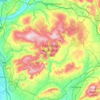
Name: Forest of Bowland AONB topographic map, elevation, terrain.
Location: Forest of Bowland AONB, Lancashire, England, United Kingdom (53.83311 -2.75988 54.12999 -2.27100)
Average elevation: 659 ft
Minimum elevation: 36 ft
Maximum elevation: 1,837 ft
Contrary to the popular histories, the origins of the name "Bowland" have nothing to do with archery ("the land of the bow") or with mediaeval cattle farms or vaccaries (Old Norse, buu-, farmstead). The name derives from the Old Norse boga-/bogi-, meaning a "bend in a river". It is a 10th-century coinage used to describe the topography of the Hodder basin, with its characteristic meandering river and brooks.
Other topographic maps
Click on a map to view its topography, its elevation and its terrain.
Preston
United Kingdom > England > Lancashire
Preston, Lancashire, England, United Kingdom
Average elevation: 190 ft
Chorley
United Kingdom > England > Lancashire
Chorley, Lancashire, England, United Kingdom
Average elevation: 371 ft
Fulwood Row
United Kingdom > England > Lancashire > Preston
Fulwood Row, Preston, Lancashire, England, PR2 9PD, United Kingdom
Average elevation: 174 ft
Lancaster
United Kingdom > England > Lancashire
Lancaster, Lancashire, England, United Kingdom
Average elevation: 276 ft
Broughton
United Kingdom > England > Lancashire > Preston
Broughton, Preston, Lancashire, England, United Kingdom
Average elevation: 141 ft
Burnley
United Kingdom > England > Lancashire
Burnley, Lancashire, England, United Kingdom
Average elevation: 810 ft
Goosnargh
United Kingdom > England > Lancashire > Preston
Goosnargh, Preston, Lancashire, England, PR3 2BB, United Kingdom
Average elevation: 220 ft
Hesketh Lane
United Kingdom > England > Lancashire > Ribble Valley
Hesketh Lane, Chipping, Ribble Valley, Lancashire, England, PR3 2TH, United Kingdom
Average elevation: 430 ft
Haggate
United Kingdom > England > Lancashire > Burnley
Haggate, Burnley, Lancashire, England, BB10 3QH, United Kingdom
Average elevation: 722 ft
Mellor
United Kingdom > England > Lancashire > Ribble Valley
Mellor, Ribble Valley, Lancashire, England, United Kingdom
Average elevation: 456 ft
Catlow
United Kingdom > England > Lancashire > Borough of Pendle > Nelson
Catlow, Nelson, Borough of Pendle, Lancashire, England, BB10 3RL, United Kingdom
Average elevation: 797 ft
Fold Head
United Kingdom > England > Lancashire > Borough of Rossendale > Healey
Fold Head, Whitworth, Healey, Borough of Rossendale, Lancashire, England, OL12 8XL, United Kingdom
Average elevation: 965 ft
Fence
United Kingdom > England > Lancashire > Borough of Pendle
Fence, Borough of Pendle, Lancashire, England, BB12 9EE, United Kingdom
Average elevation: 614 ft
Becconsall
United Kingdom > England > Lancashire > West Lancashire
Becconsall, West Lancashire, Lancashire, England, PR4 6SN, United Kingdom
Average elevation: 33 ft
Lower Bartle
United Kingdom > England > Lancashire > Preston > Woodplumpton
Lower Bartle, Woodplumpton, Preston, Lancashire, England, PR4 0RX, United Kingdom
Average elevation: 98 ft
Borough of Rossendale
United Kingdom > England > Lancashire
Borough of Rossendale, Lancashire, England, United Kingdom
Average elevation: 896 ft
Rivington Pike
United Kingdom > England > Lancashire > Horwich
Rivington Pike, Georges Lane, Rivington, Horwich, Chorley, Lancashire, Greater Manchester, England, BL6 6RU, United Kingdom
Average elevation: 886 ft
Borough of Fylde
United Kingdom > England > Lancashire
Borough of Fylde, Lancashire, England, United Kingdom
Average elevation: 43 ft
White Coppice
United Kingdom > England > Lancashire > Chorley
White Coppice, Anglezarke, Chorley, Lancashire, England, PR6 9DB, United Kingdom
Average elevation: 604 ft
Lancaster Canal
United Kingdom > England > Lancashire
Lancaster Canal, Lancashire, England, United Kingdom
Average elevation: 322 ft
Hardhorn
United Kingdom > England > Lancashire > Borough of Wyre
Hardhorn, Borough of Wyre, Lancashire, England, FY6 8DN, United Kingdom
Average elevation: 43 ft
Little Thornton
United Kingdom > England > Lancashire > Borough of Wyre
Little Thornton, Borough of Wyre, Lancashire, England, FY5 5LU, United Kingdom
Average elevation: 26 ft
Silverdale
United Kingdom > England > Lancashire > Lancaster
Silverdale, Lancaster, Lancashire, England, United Kingdom
Average elevation: 52 ft
Samlesbury
United Kingdom > England > Lancashire > South Ribble
Samlesbury, South Ribble, Lancashire, England, United Kingdom
Average elevation: 190 ft
Arkholme
United Kingdom > England > Lancashire > Lancaster
Arkholme, Lancaster, Lancashire, England, LA6 1RA, United Kingdom
Average elevation: 187 ft
Read
United Kingdom > England > Lancashire > Ribble Valley
Read, Ribble Valley, Lancashire, England, United Kingdom
Average elevation: 374 ft
Stodday
United Kingdom > England > Lancashire > Lancaster
Stodday, Aldcliffe-with-Stodday, Lancaster, Lancashire, England, LA2 0AG, United Kingdom
Average elevation: 85 ft
Over Kellet
United Kingdom > England > Lancashire > Lancaster
Over Kellet, Lancaster, Lancashire, England, United Kingdom
Average elevation: 226 ft
Whitewell Bottom
United Kingdom > England > Lancashire > Borough of Rossendale > Sagar Holme
Whitewell Bottom, Sagar Holme, Borough of Rossendale, Lancashire, England, BB4 9DE, United Kingdom
Average elevation: 922 ft
Gisburn
United Kingdom > England > Lancashire > Ribble Valley
Gisburn, Ribble Valley, Lancashire, England, United Kingdom
Average elevation: 525 ft
Hayshaw Fell
United Kingdom > England > Lancashire > Lancaster
Hayshaw Fell, Over Wyresdale, Lancaster, Lancashire, England, LA2 9DW, United Kingdom
Average elevation: 741 ft
Lytham St Annes
United Kingdom > England > Lancashire > Borough of Fylde
Lytham St Annes, Borough of Fylde, Lancashire, England, FY8 4AR, United Kingdom
Average elevation: 16 ft
Old Langho
United Kingdom > England > Lancashire > Ribble Valley > Brockhall Village
Old Langho, Billington and Langho, Brockhall Village, Ribble Valley, Lancashire, England, BB6 8AP, United Kingdom
Average elevation: 243 ft
Wray-with-Botton
United Kingdom > England > Lancashire > Lancaster
Wray-with-Botton, Lancaster, Lancashire, England, United Kingdom
Average elevation: 856 ft
Parlick
United Kingdom > England > Lancashire > Borough of Wyre
Parlick, Borough of Wyre, Lancashire, England, PR3 2NZ, United Kingdom
Average elevation: 823 ft
Warton Crag
United Kingdom > England > Lancashire > Lancaster > Warton
Warton Crag, Trig Point to Cleft Stone, Warton, Lancaster, Lancashire, England, LA5 9NE, United Kingdom
Average elevation: 148 ft
West Lancashire
United Kingdom > England > Lancashire
West Lancashire, Lancashire, England, United Kingdom
Average elevation: 98 ft
Billington and Langho
United Kingdom > England > Lancashire > Ribble Valley > Brockhall Village
Billington and Langho, Brockhall Village, Ribble Valley, Lancashire, England, United Kingdom, Chew Bank Wood
Average elevation: 190 ft
Brungerley Park
United Kingdom > England > Lancashire > Ribble Valley > Clitheroe > Waddington
Brungerley Park, Clitheroe, Waddington, Ribble Valley, Lancashire, England, United Kingdom
Average elevation: 253 ft
Warton Bank
United Kingdom > England > Lancashire > Borough of Fylde > Warton
Warton Bank, Bryning-with-Warton, Warton, Borough of Fylde, Lancashire, England, PR4 1TB, United Kingdom
Average elevation: 26 ft
Leyland
United Kingdom > England > Lancashire > South Ribble
Leyland, South Ribble, Lancashire, England, PR25 2EX, United Kingdom
Average elevation: 135 ft
Billington
United Kingdom > England > Lancashire > Ribble Valley
Billington, Ribble Valley, Lancashire, England, BB7 9NG, United Kingdom
Average elevation: 292 ft
Ewood Bridge
United Kingdom > England > Lancashire > Borough of Rossendale
Ewood Bridge, Borough of Rossendale, Lancashire, England, BB4 6LZ, United Kingdom
Average elevation: 741 ft
Whitewell
United Kingdom > England > Lancashire > Ribble Valley
Whitewell, Bowland Forest Low, Ribble Valley, Lancashire, England, BB7 3AT, United Kingdom
Average elevation: 604 ft
Ormskirk
United Kingdom > England > Lancashire > West Lancashire
Ormskirk, West Lancashire, Lancashire, England, L39 2XN, United Kingdom
Average elevation: 128 ft
Brookhouse
United Kingdom > England > Lancashire > Lancaster
Brookhouse, Lancaster, Lancashire, England, LA2 9PA, United Kingdom
Average elevation: 269 ft
Capernwray
United Kingdom > England > Lancashire > Lancaster
Capernwray, Over Kellet, Lancaster, Lancashire, England, LA6 1AE, United Kingdom
Average elevation: 197 ft
Poulton-le-Fylde
United Kingdom > England > Lancashire > Borough of Wyre
Poulton-le-Fylde, Borough of Wyre, Lancashire, England, FY6 7BL, United Kingdom
Average elevation: 39 ft
Farington Moss
United Kingdom > England > Lancashire > South Ribble
Farington Moss, South Ribble, Lancashire, England, PR26 6RD, United Kingdom
Average elevation: 118 ft
River Brock
United Kingdom > England > Lancashire > Borough of Wyre
River Brock, Borough of Wyre, Lancashire, England, United Kingdom
Average elevation: 364 ft