Geolocate

Saint Hedwig topographic map

Click on the map to display elevation.

About this map

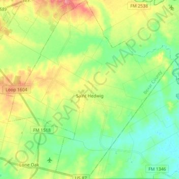
Name: Saint Hedwig topographic map, elevation, terrain.

Location: Saint Hedwig, Bexar County, Texas, 78152, United States (29.35815 -98.27311 29.47882 -98.13511)

Average elevation: 568 ft

Minimum elevation: 476 ft

Maximum elevation: 722 ft

Bexar County trails, hiking, mountain biking, running and outdoor activities

Other topographic maps

Click on a map to view its topography, its elevation and its terrain.

San Antonio

United States > Texas > Bexar County > San Antonio

Average elevation: 715 ft

Sedona

United States > Texas > Bexar County > San Antonio

Average elevation: 988 ft

Comanche Lookout

United States > Texas > Bexar County > San Antonio

Average elevation: 932 ft

Lions Park Lake

United States > Texas > Bexar County > San Antonio

Average elevation: 614 ft

Eldorado Lake

United States > Texas > Bexar County > San Antonio

Average elevation: 820 ft

Mount Smith

United States > Texas > Bexar County

Average elevation: 1,690 ft

Gear up for your next adventure:

🏫Relief Map Kits - Hands-on tools for teaching landforms and elevation
🛡️Bear Spray Outdoor - Protection in bear country hikes
🧯Portable Fire Pit - Compact fire pit for camping spots
🧢Sun Protection Hats - Wide-brimmed and UPF-rated hats for high-altitude sun safety
🎁Geography Themed Gifts - Unique gift ideas for map lovers and geography enthusiasts

As an Amazon Associate, this site earns from qualifying purchases at no extra cost to you.