
Mount Smith topographic map
Click on the map to display elevation.
About this map
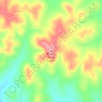
Name: Mount Smith topographic map, elevation, terrain.
Location: Mount Smith, Bexar County, Texas, United States (29.68795 -98.76313 29.68805 -98.76303)
Average elevation: 1,690 ft
Minimum elevation: 1,490 ft
Maximum elevation: 1,896 ft
Other topographic maps
Click on a map to view its topography, its elevation and its terrain.
San Antonio
United States > Texas > Bexar County
San Antonio features a diverse topography characterized by gently rolling hills and flat plains. The city's elevation averages around 650 feet above sea level, but nearby areas can reach heights of up to 1,300 feet in certain locations like Cross Mountain. The landscape is part of the southern edge of the…
Average elevation: 810 ft
San Antonio
United States > Texas > Bexar County
San Antonio is approximately 75 miles (121 km) to the southwest of its neighboring city, Austin, the state capital, about 190 miles (310 km) west of Houston, and about 250 miles (400 km) south of the Dallas–Fort Worth area. The city has a total area of 465.4 square miles (1,205.4 km2); 460.93 square miles…
Average elevation: 810 ft
San Antonio
United States > Texas > Bexar County
San Antonio is approximately 75 miles (121 km) to the southwest of its neighboring city, Austin, the state capital, about 150 miles (240 km) from the Mexico-United States border, about 190 miles (310 km) west of Houston, and about 250 miles (400 km) south of the Dallas–Fort Worth area. The city has a total…
Average elevation: 810 ft
San Antonio
United States > Texas > Bexar County
San Antonio is approximately 75 miles (121 km) to the southwest of its neighboring city, Austin, the state capital, about 150 miles (240 km) from the Mexican border, about 190 miles (310 km) west of Houston, and about 250 miles (400 km) south of the Dallas–Fort Worth area. The city has a total area of 465.4…
Average elevation: 810 ft
San Antonio
United States > Texas > Bexar County
San Antonio is approximately 75 miles (121 km) to the southwest of its neighboring city, Austin, the state capital, about 190 miles (310 km) west of Houston, and about 250 miles (400 km) south of the Dallas–Fort Worth area. The city has a total area of 465.4 square miles (1,205.4 km2); 460.93 square miles…
Average elevation: 810 ft
San Antonio
United States > Texas > Bexar County
San Antonio is approximately 75 miles (121 km) to the southwest of its neighboring city, Austin, the state capital, about 150 miles (240 km) from the Mexican border, about 190 miles (310 km) west of Houston, and about 250 miles (400 km) south of the Dallas–Fort Worth area. The city has a total area of 465.4…
Average elevation: 810 ft
Medina River Natural Area
United States > Texas > Bexar County > San Antonio
Average elevation: 551 ft
San Antonio
United States > Texas > Bexar County
San Antonio is approximately 75 miles (121 km) to the southwest of its neighboring city, Austin, the state capital, about 150 miles (240 km) from the Mexican border, about 190 miles (310 km) west of Houston, and about 250 miles (400 km) south of the Dallas–Fort Worth area. The city has a total area of 465.4…
Average elevation: 810 ft
San Antonio
United States > Texas > Bexar County
San Antonio is approximately 75 miles (121 km) to the southwest of its neighboring city, Austin, the state capital, about 150 miles (240 km) from the Mexico-United States border, about 190 miles (310 km) west of Houston, and about 250 miles (400 km) south of the Dallas–Fort Worth area. The city has a total…
Average elevation: 810 ft
San Antonio
United States > Texas > Bexar County
San Antonio is approximately 75 miles (121 km) to the southwest of its neighboring city, Austin, the state capital, about 190 miles (310 km) west of Houston, and about 250 miles (400 km) south of the Dallas–Fort Worth area. The city has a total area of 465.4 square miles (1,205.4 km2); 460.93 square miles…
Average elevation: 810 ft