
Make a donation
Gear up for your next adventure:
As an Amazon Associate, this site earns from qualifying purchases at no extra cost to you.
Albringhausen topographic map
Click on the map to display elevation.
Make a donation
Gear up for your next adventure:
As an Amazon Associate, this site earns from qualifying purchases at no extra cost to you.
About this map
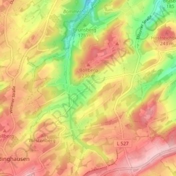
Name: Albringhausen topographic map, elevation, terrain.
Average elevation: 663 ft
Minimum elevation: 361 ft
Maximum elevation: 876 ft
Make a donation
Gear up for your next adventure:
As an Amazon Associate, this site earns from qualifying purchases at no extra cost to you.
Other topographic maps
Click on a map to view its topography, its elevation and its terrain.
Grundschöttel
Deutschland > Nordrhein-Westfalen > Ennepe-Ruhr-Kreis > Wetter (Ruhr)
Average elevation: 630 ft
Volmarstein
Deutschland > Nordrhein-Westfalen > Ennepe-Ruhr-Kreis > Wetter (Ruhr)
Den tiefsten Punkt im Stadtteil bildet mit etwa 81 m ü. NN Höhe (mittlerer Wasserstand) die Ruhr ganz im Norden der Gemarkung Volmarstein. Der höchste Punkt befindet sich im Bereich Am Südhang (266 m ü. NN) in der Gemarkung Grundschöttel an der Grenze zu Silschede.
Average elevation: 430 ft
Harkortturm
Deutschland > Nordrhein-Westfalen > Ennepe-Ruhr-Kreis > Wetter (Ruhr)
Aus einem 1882 durchgeführten Architektenwettbewerb ging der gemeinsame Entwurf der Düsseldorfer Architekten Otto van Els und Bruno Schmitz siegreich hervor. Nachdem die Architekten einige Änderungswünsche der Bauherrschaft eingearbeitet hatten, ergab sich ein Kostenvoranschlag in Höhe von 20.000 Mark –…
Average elevation: 463 ft
Alt-Wetter
Deutschland > Nordrhein-Westfalen > Ennepe-Ruhr-Kreis > Wetter (Ruhr)
Average elevation: 397 ft
Make a donation
Gear up for your next adventure:
As an Amazon Associate, this site earns from qualifying purchases at no extra cost to you.
Esborn
Deutschland > Nordrhein-Westfalen > Ennepe-Ruhr-Kreis > Wetter (Ruhr)
Der höchste Punkt in der Gemarkung ist die Anhöhe Am Hülsey (253 m ü. NN); der nördlich von Voßhöfen liegende Höstreichberg (243 m ü. NN) gehört ebenfalls zu Esborn. Die beiden mit jeweils 112 m ü. NN tiefsten Punkte befinden sich an den Bachbetten von Elbsche und Schmalenbecke.
Average elevation: 594 ft