Geolocate

4th district topographic map

Click on the map to display elevation.

About this map

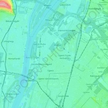
Name: 4th district topographic map, elevation, terrain.

Location: 4th district, Budapest, Central Hungary, Hungary (47.54232 19.06720 47.61315 19.12346)

Average elevation: 364 ft

Minimum elevation: 308 ft

Maximum elevation: 682 ft

Other topographic maps

Click on a map to view its topography, its elevation and its terrain.

Danube

Hungary > Budapest

Average elevation: 374 ft

Kis-Sváb-hegy

Hungary > Budapest

Average elevation: 640 ft

Gellért Hill

Hungary > Budapest

Average elevation: 413 ft

Csúcs-hegy

Hungary > Budapest

Average elevation: 856 ft

Gellért Hill

Hungary > Budapest

Average elevation: 413 ft

Ziggurat

Hungary > Budapest

Average elevation: 354 ft

Tigers

Hungary > Budapest

Average elevation: 364 ft

Danube

Hungary > Budapest

Average elevation: 410 ft

Gear up for your next adventure:

🧥Men's Rain Shells - Premium waterproof and breathable jackets for mountain weather
🔦Compact Flashlight - Reliable flashlight for emergencies
🏥Hiking First Aid Kits - Comprehensive medical kits for remote trail injuries
🌧️Backpack Rain Cover - Keep gear dry in wet weather
🌡️Handheld Weather Meters - Measure wind, temp, and pressure for safe mountain travel

As an Amazon Associate, this site earns from qualifying purchases at no extra cost to you.