Geolocate

Danube topographic map

Click on the map to display elevation.

About this map

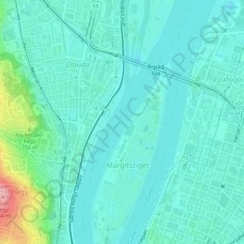
Name: Danube topographic map, elevation, terrain.

Location: Danube, Budapest, Central Hungary, 1036, Hungary (47.53105 19.04551 47.53295 19.04701)

Average elevation: 374 ft

Minimum elevation: 295 ft

Maximum elevation: 738 ft

Other topographic maps

Click on a map to view its topography, its elevation and its terrain.

Kis-Sváb-hegy

Hungary > Budapest

Average elevation: 640 ft

Budafok

Hungary > Budapest

Average elevation: 413 ft

Népsziget

Hungary > Budapest

Average elevation: 351 ft

Infopark

Hungary > Budapest

Average elevation: 358 ft

15th district

Hungary > Budapest

Average elevation: 397 ft

18th district

Hungary > Budapest

Average elevation: 417 ft

11th district

Hungary > Budapest

Average elevation: 456 ft

Gellért Hill

Hungary > Budapest

Average elevation: 413 ft

2nd district

Hungary > Budapest

Average elevation: 827 ft

Hármashatárhegy

Hungary > Budapest

Average elevation: 958 ft

5th district

Hungary > Budapest

Average elevation: 400 ft

5th district

Hungary > Budapest

Average elevation: 400 ft

1123

Hungary > Budapest

Average elevation: 525 ft

11th district

Hungary > Budapest

Average elevation: 456 ft

8th district

Hungary > Budapest

Average elevation: 377 ft

9th district

Hungary > Budapest

Average elevation: 367 ft

10th district

Hungary > Budapest

Average elevation: 423 ft

1119

Hungary > Budapest

Average elevation: 367 ft

Ziggurat

Hungary > Budapest

Average elevation: 354 ft

13th district

Hungary > Budapest

Average elevation: 361 ft

5th district

Hungary > Budapest

Average elevation: 400 ft

1st district

Hungary > Budapest

Average elevation: 449 ft

23rd district

Hungary > Budapest

Average elevation: 364 ft

Istenhegy

Hungary > Budapest

Average elevation: 810 ft

16th district

Hungary > Budapest

Average elevation: 499 ft

6th district

Hungary > Budapest

Average elevation: 374 ft

6th district

Hungary > Budapest

Average elevation: 374 ft

1075

Hungary > Budapest

Average elevation: 387 ft

9th district

Hungary > Budapest

Average elevation: 367 ft

10th district

Hungary > Budapest

Average elevation: 423 ft

13th district

Hungary > Budapest

Average elevation: 361 ft

1025

Hungary > Budapest

Average elevation: 837 ft

3rd district

Hungary > Budapest

Average elevation: 538 ft

7th district

Hungary > Budapest

Average elevation: 377 ft

1095

Hungary > Budapest

Average elevation: 351 ft

Békásmegyer

Hungary > Budapest

Average elevation: 417 ft

Csúcs-hegy

Hungary > Budapest

Average elevation: 856 ft

Gellért Hill

Hungary > Budapest

Average elevation: 413 ft

8th district

Hungary > Budapest

Average elevation: 377 ft

2nd district

Hungary > Budapest

Average elevation: 827 ft

14th district

Hungary > Budapest

Average elevation: 381 ft

City Park

Hungary > Budapest

Average elevation: 371 ft

21st district

Hungary > Budapest

Average elevation: 361 ft

Infopark

Hungary > Budapest

Average elevation: 358 ft

22nd district

Hungary > Budapest

Average elevation: 413 ft

1st district

Hungary > Budapest

Average elevation: 449 ft

11th district

Hungary > Budapest

Average elevation: 456 ft

11th district

Hungary > Budapest

Average elevation: 456 ft

4th district

Hungary > Budapest

Average elevation: 364 ft

14th district

Hungary > Budapest

Average elevation: 381 ft

18th district

Hungary > Budapest

Average elevation: 417 ft

Gear up for your next adventure:

🧤Tactile Hiking Gloves - Keep hands warm while operating GPS and smartphone screens
🔦LED Headlamp - Bright and durable LED headlamp for night navigation
🌡️Handheld Weather Meters - Measure wind, temp, and pressure for safe mountain travel
🪶Multi‑Purpose Knife - Useful blade for camp and trail
🧭Map Reading Tools - Tools and kits for map navigation

As an Amazon Associate, this site earns from qualifying purchases at no extra cost to you.