Geolocate

Flatschach topographic map

Click on the map to display elevation.

About this map

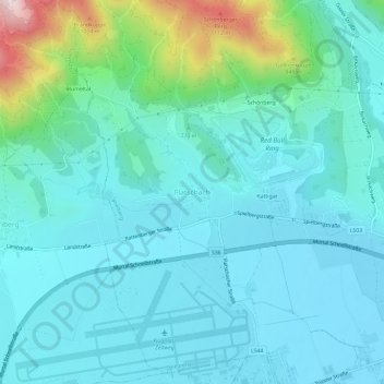
Name: Flatschach topographic map, elevation, terrain.

Location: Flatschach, Spielberg, Bezirk Murtal, Styria, 8720, Austria (47.19848 14.73128 47.23848 14.77128)

Average elevation: 2,464 ft

Minimum elevation: 2,159 ft

Maximum elevation: 3,970 ft

Other topographic maps

Click on a map to view its topography, its elevation and its terrain.

Pölstal

Austria > Styria > Bezirk Murtal

Average elevation: 4,928 ft

Spielberg

Austria > Styria > Bezirk Murtal

Average elevation: 2,431 ft

Spielberg

Austria > Styria > Bezirk Murtal

Average elevation: 2,431 ft

St. Peter ob Judenburg

Austria > Styria > Bezirk Murtal

Average elevation: 3,839 ft

Judenburg

Austria > Styria > Bezirk Murtal

Average elevation: 3,356 ft

Gear up for your next adventure:

📱Solar Portable Charger - Solar power bank for charging devices off‑grid
🖼️Topo Map Wall Art - Decorative topographic prints of famous peaks and regions
🛠️Backpacking Tool Kit - Essential toolkit for outdoor repairs
🎒Gear Packing Cubes - Organize your backpack efficiently
🪄Magnetic Compass - Accurate compass for navigation

As an Amazon Associate, this site earns from qualifying purchases at no extra cost to you.