Geolocate

Judenburg topographic map

Click on the map to display elevation.

About this map

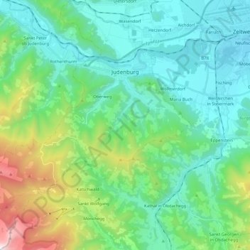
Name: Judenburg topographic map, elevation, terrain.

Location: Judenburg, Bezirk Murtal, Styria, 8750, Austria (47.07176 14.54010 47.20826 14.71290)

Average elevation: 3,356 ft

Minimum elevation: 2,126 ft

Maximum elevation: 7,723 ft

Other topographic maps

Click on a map to view its topography, its elevation and its terrain.

Flatschach

Austria > Styria > Bezirk Murtal

Average elevation: 2,464 ft

Alm Rainer

Austria > Styria > Bezirk Murtal > Judenburg > Reifling

Average elevation: 3,501 ft

Hetzendorf

Austria > Styria > Bezirk Murtal

Average elevation: 2,333 ft

Kattigar

Austria > Styria > Bezirk Murtal > Flatschach

Average elevation: 2,388 ft

Kattigar

Austria > Styria > Bezirk Murtal > Flatschach

Average elevation: 2,388 ft

Kattigar

Austria > Styria > Bezirk Murtal > Flatschach

Average elevation: 2,388 ft

Alm Rainer

Austria > Styria > Bezirk Murtal > Judenburg > Reifling

Average elevation: 3,501 ft

Unzmarkt

Austria > Styria > Bezirk Murtal > Unzmarkt-Frauenburg

Average elevation: 3,310 ft

Schönberg

Austria > Styria > Bezirk Murtal > Flatschach

Average elevation: 2,644 ft

Flatschach

Austria > Styria > Bezirk Murtal > Flatschach

Average elevation: 2,464 ft

Alm Rainer

Austria > Styria > Bezirk Murtal > Judenburg > Reifling

Average elevation: 3,501 ft

Gear up for your next adventure:

📦Dry Bags Set - Waterproof storage for electronics and clothes
🎁Geography Themed Gifts - Unique gift ideas for map lovers and geography enthusiasts
📱Heavy-Duty Phone Cases - Drop-proof and waterproof protection for outdoor navigation
🏕️Family Camping Gear - Essentials for group camping trips
🎒Hydration Pack - Hands‑free water reservoir for long hikes

As an Amazon Associate, this site earns from qualifying purchases at no extra cost to you.