Geolocate

Penarth topographic map

Click on the map to display elevation.

About this map

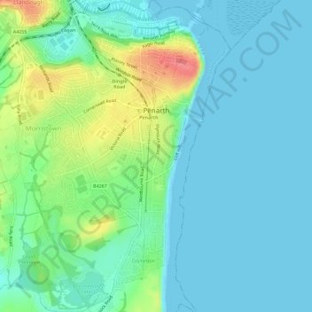
Name: Penarth topographic map, elevation, terrain.

Location: Penarth, Vale of Glamorgan, Wales, United Kingdom (51.41308 -3.20291 51.44846 -3.15970)

Average elevation: 56 ft

Minimum elevation: 0 ft

Maximum elevation: 220 ft

Other topographic maps

Click on a map to view its topography, its elevation and its terrain.

Eglwys Brewis

United Kingdom > Wales > Vale of Glamorgan

Average elevation: 157 ft

Dyffryn

United Kingdom > Wales > Vale of Glamorgan

Average elevation: 240 ft

St Donats

United Kingdom > Wales > Vale of Glamorgan

Average elevation: 141 ft

Gear up for your next adventure:

🚁Photography Drones - Capture stunning aerial views of landforms and topography
🌄Hiking Binoculars - Compact binoculars for scenic views and trail spotting
🏥Hiking First Aid Kits - Comprehensive medical kits for remote trail injuries
GPS Sports Watch - GPS watch for running, hiking and training
🛏️Cold Weather Sleeping Bag - Warm sleeping bag for cold conditions

As an Amazon Associate, this site earns from qualifying purchases at no extra cost to you.