Geolocate

Ponda topographic map

Click on the map to display elevation.

About this map

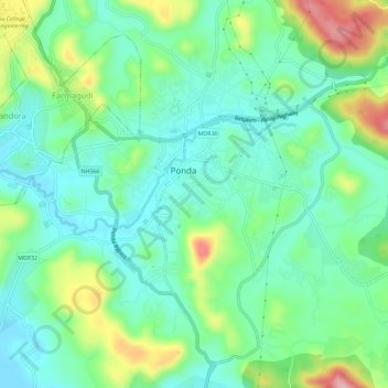
Name: Ponda topographic map, elevation, terrain.

Location: Ponda, South Goa, Goa, 403401, India (15.37638 73.98238 15.41891 74.03991)

Average elevation: 203 ft

Minimum elevation: 0 ft

Maximum elevation: 696 ft

Other topographic maps

Click on a map to view its topography, its elevation and its terrain.

Shiroda

India > Goa > Ponda

Average elevation: 108 ft

Gear up for your next adventure:

🛠️Outdoor Gear Repair Kit - Essential tools to fix gear on the trail
🛡️Insect Repellent - Protection against bugs during outdoor activities
🧥Men's Rain Shells - Premium waterproof and breathable jackets for mountain weather
🥾Hiking Shoes - Durable and comfortable shoes for trail hiking
🪓Survival Multi‑Tool - Versatile tool for camp and trail tasks

As an Amazon Associate, this site earns from qualifying purchases at no extra cost to you.