
Hiko topographic map
Click on the map to display elevation.
Hiko
The Hiko and Crystal Springs provide a large supply of water for the Hiko farms and ranches. The Hiko farming community is located in the north end of the Pahranagat Valley and lies at an elevation of 3,869 feet (1,179 m), with a ZIP code of 89017.
About this map
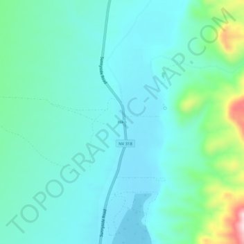
Name: Hiko topographic map, elevation, terrain.
Location: Hiko, Lincoln County, Nevada, United States (37.57606 -115.24424 37.61606 -115.20424)
Average elevation: 4,045 ft
Minimum elevation: 3,835 ft
Maximum elevation: 4,938 ft
Lincoln County trails, hiking, mountain biking, running and outdoor activities
Other topographic maps
Click on a map to view its topography, its elevation and its terrain.