
Leh topographic map
Interactive map
Click on the map to display elevation.
About this map
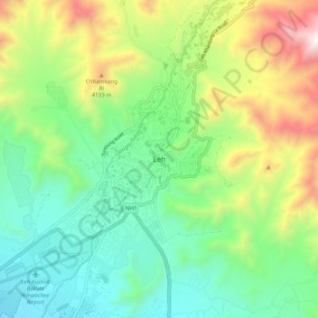
Name: Leh topographic map, elevation, terrain.
Location: Leh, Leh Tehsil, Leh District, Ladakh, India (34.12420 77.54481 34.20420 77.62481)
Average elevation: 11,985 ft
Minimum elevation: 10,518 ft
Maximum elevation: 15,000 ft
Leh (/ˈlɛ/) (Ladakhi: གླེ) is the joint capital and largest city of Ladakh, a union territory of India. Leh, located in the Leh district, was also the historical capital of the Kingdom of Ladakh, the seat of which was in the Leh Palace, the former residence of the royal family of Ladakh, built in the same style and about the same time as the Potala Palace in Tibet. Leh is at an altitude of 3,524 m (11,562 ft), and is connected via National Highway 1 to Srinagar in the southwest and to Manali in the south via the Leh-Manali Highway (part of National Highway 3 connect leh).
Other topographic maps
Click on a map to view its topography, its elevation and its terrain.
Koyul
India > Ladakh > Leh Tehsil
Koyul, Leh Tehsil, Leh District, Ladakh, India
Average elevation: 14,436 ft
Leh Palace
India > Ladakh > Leh Tehsil > Leh
Leh Palace, Sankar Road, Zangsti, Leh, Leh Tehsil, Leh District, Ladakh, India
Average elevation: 11,699 ft
Hanle
India > Ladakh > Leh Tehsil
Hanle, Leh Tehsil, Leh district, Ladakh, India
Average elevation: 14,065 ft
Karu
India > Ladakh > Leh Tehsil
Karu, Leh Tehsil, Leh district, Ladakh, 194201, India
Average elevation: 11,325 ft
Rasar La
India > Ladakh > Leh Tehsil
Rasar La, Leh Tehsil, Leh district, Ladakh, India
Average elevation: 17,897 ft
Chushul
India > Ladakh > Leh Tehsil > Chushul
Chushul, Leh Tehsil, Leh district, Ladakh, India
Average elevation: 14,419 ft
Indus
India > Ladakh > Leh Tehsil
Indus, Leh Tehsil, Leh District, Ladakh, India
Average elevation: 13,753 ft
Karzok
India > Ladakh > Leh Tehsil > Karzok
Karzok, Leh Tehsil, Leh district, Ladakh, India
Average elevation: 15,151 ft
Tso Moriri
India > Ladakh > Leh Tehsil > Karzok
Tso Moriri, Karzok, Leh Tehsil, Leh district, Ladakh, India
Average elevation: 16,549 ft
Kiari
India > Ladakh > Leh Tehsil > Kiari
Kiari, Leh Tehsil, Leh district, Ladakh, India
Average elevation: 13,999 ft