Geolocate

Whitingham topographic map

Click on the map to display elevation.

About this map

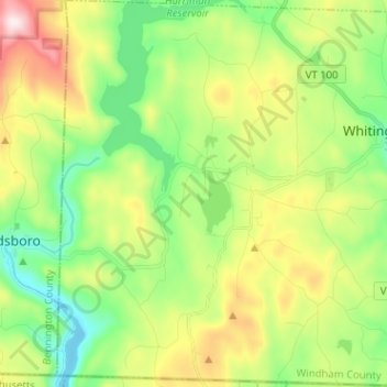
Name: Whitingham topographic map, elevation, terrain.

Location: Whitingham, Windham County, Vermont, United States (42.73641 -72.93010 42.82981 -72.80305)

Average elevation: 1,768 ft

Minimum elevation: 1,096 ft

Maximum elevation: 2,966 ft

Windham County trails, hiking, mountain biking, running and outdoor activities

Other topographic maps

Click on a map to view its topography, its elevation and its terrain.

West Guilford

United States > Vermont > Windham County > Guilford

Average elevation: 1,129 ft

Guilford Center

United States > Vermont > Windham County > Guilford

Average elevation: 866 ft

Sherwood Forest

United States > Vermont > Windham County > Londonderry

Average elevation: 1,371 ft

North Windham

United States > Vermont > Windham County > Londonderry

Average elevation: 1,699 ft

East Dover

United States > Vermont > Windham County > Dover

Average elevation: 1,394 ft

East Dover

United States > Vermont > Windham County > Dover

Average elevation: 1,394 ft

Kenny Pond Dam

United States > Vermont > Windham County > Newfane

Average elevation: 1,355 ft

South Newfane

United States > Vermont > Windham County > Newfane

Average elevation: 1,053 ft

Mount Snow

United States > Vermont > Windham County

Average elevation: 2,838 ft

West Dover

United States > Vermont > Windham County > Dover

Average elevation: 1,913 ft

Packer Corner

United States > Vermont > Windham County > Guilford

Average elevation: 1,001 ft

West Townshend

United States > Vermont > Windham County > Townshend

Average elevation: 968 ft

Sherwood Forest

United States > Vermont > Windham County > Londonderry

Average elevation: 1,371 ft

Mount Snow

United States > Vermont > Windham County

Average elevation: 2,835 ft

Stratton Mountain

United States > Vermont > Windham County > Stratton

Average elevation: 3,268 ft

Williamsville

United States > Vermont > Windham County > Newfane

Average elevation: 886 ft

Wilmington

United States > Vermont > Windham County > Wilmington > Wilmington

Wilmington experiences a humid continental climate (Koppen Dfb) with warm, humid summers and cold (sometimes severely cold) winters. While snowfall can vary greatly from year to year in nearby towns like Bennington and Brattleboro, Wilmington's snowfall is consistently heavy each year because of its elevation…

Average elevation: 1,690 ft

Gear up for your next adventure:

🗺️NatGeo Topo Maps - High-quality waterproof printed topographic maps of US Parks
🛶Inflatable Kayak - Portable kayak for rivers, lakes, and expeditions
🧣Hiking Neck Gaiter - Multi‑use neck protection for outdoor weather
🚁Photography Drones - Capture stunning aerial views of landforms and topography
🔌Solar Panel Charger - Charge gear sustainably outdoors

As an Amazon Associate, this site earns from qualifying purchases at no extra cost to you.