
Mount Snow topographic map
Click on the map to display elevation.
About this map
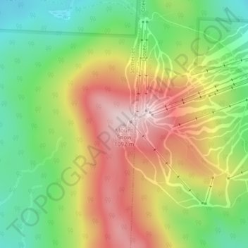
Name: Mount Snow topographic map, elevation, terrain.
Location: Mount Snow, Windham County, Vermont, 05356, United States (42.95920 -72.92381 42.95930 -72.92371)
Average elevation: 2,835 ft
Minimum elevation: 2,188 ft
Maximum elevation: 3,579 ft
Windham County trails, hiking, mountain biking, running and outdoor activities
Other topographic maps
Click on a map to view its topography, its elevation and its terrain.
Brattleboro
United States > Vermont > Windham County
The town's densely populated center is located near Vermont's lowest elevation point in the Connecticut river valley. Because of the surrounding steep hills there is very little flat land, and many of its buildings and houses are situated on steep hillsides, necessarily closely bunched together. This…
Average elevation: 604 ft
Jamaica
United States > Vermont > Windham County
The charter goes on to say “that the same be and is hereby Incorporated into a Township by the name of Jamaica”—its name from the Natick word for beaver and not the Caribbean island. The grant encompassed forty-two square miles, at an altitude ranging from 688 feet (210 m) above sea level along the West…
Average elevation: 1,375 ft
South Londonderry
United States > Vermont > Windham County > Londonderry > South Londonderry Village Historic District
Average elevation: 1,198 ft
Wilmington
United States > Vermont > Windham County
Wilmington experiences a humid continental climate (Koppen Dfb) with warm, humid summers and cold (sometimes severely cold) winters. While snowfall can vary greatly from year to year in nearby towns like Bennington and Brattleboro, Wilmington's snowfall is consistently heavy each year because of its elevation…
Average elevation: 1,896 ft
Rockingham
United States > Vermont > Windham County
The highest point in town is Berry Hill at 478 m/1568 ft elevation, near the northwestern corner of the town. The lowest point is on the Connecticut River at the southern boundary of town, at 73 m/240 ft elevation.
Average elevation: 745 ft
Rockingham
United States > Vermont > Windham County
The highest point in town is Berry Hill at 478 m/1568 ft elevation, near the northwestern corner of the town. The lowest point is on the Connecticut River at the southern boundary of town, at 73 m/240 ft elevation.
Average elevation: 692 ft
Jamaica
United States > Vermont > Windham County
The charter goes on to say “that the same be and is hereby Incorporated into a Township by the name of Jamaica”—its name from the Natick word for beaver and not the Caribbean island. The grant encompassed forty-two square miles, at an altitude ranging from 688 feet (210 m) above sea level along the West…
Average elevation: 1,375 ft
Wilmington
United States > Vermont > Windham County
Wilmington experiences a humid continental climate (Koppen Dfb) with warm, humid summers and cold (sometimes severely cold) winters. While snowfall can vary greatly from year to year in nearby towns like Bennington and Brattleboro, Wilmington's snowfall is consistently heavy each year because of its elevation…
Average elevation: 1,896 ft
Brattleboro
United States > Vermont > Windham County
The town's densely populated center is located near Vermont's lowest elevation point in the Connecticut river valley. Because of the surrounding steep hills there is very little flat land, and many of its buildings and houses are situated on steep hillsides, necessarily closely bunched together. This…
Average elevation: 604 ft