
Thank you for supporting this site ❤️
Make a donation
Make a donation
Gear up for your next adventure:
As an Amazon Associate, this site earns from qualifying purchases at no extra cost to you.
Sharpsburg topographic map
Click on the map to display elevation.
Thank you for supporting this site ❤️
Make a donation
Make a donation
Gear up for your next adventure:
As an Amazon Associate, this site earns from qualifying purchases at no extra cost to you.
About this map
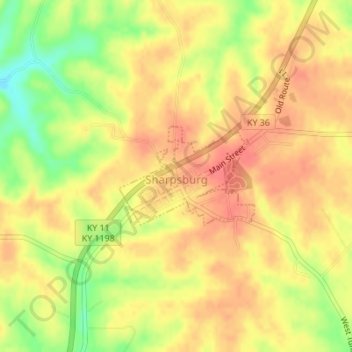
Name: Sharpsburg topographic map, elevation, terrain.
Location: Sharpsburg, Bath County, Kentucky, United States (38.19848 -83.93500 38.20608 -83.92175)
Average elevation: 974 ft
Minimum elevation: 850 ft
Maximum elevation: 1,043 ft
Bath County trails, hiking, mountain biking, running and outdoor activities
Thank you for supporting this site ❤️
Make a donation
Make a donation
Gear up for your next adventure:
As an Amazon Associate, this site earns from qualifying purchases at no extra cost to you.
Other topographic maps
Click on a map to view its topography, its elevation and its terrain.
Pioneer Weapons Wildlife Management Area
United States > Kentucky > Bath County
Average elevation: 1,060 ft