Geolocate

Olympia topographic map

Click on the map to display elevation.

About this map

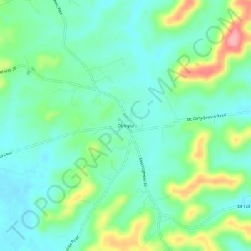
Name: Olympia topographic map, elevation, terrain.

Location: Olympia, Bath County, Kentucky, 40358, United States (38.07814 -83.71575 38.11814 -83.67575)

Average elevation: 814 ft

Minimum elevation: 702 ft

Maximum elevation: 1,086 ft

Bath County trails, hiking, mountain biking, running and outdoor activities

Other topographic maps

Click on a map to view its topography, its elevation and its terrain.

Sharpsburg

United States > Kentucky > Bath County

Average elevation: 974 ft

Salt Lick

United States > Kentucky > Bath County

Average elevation: 712 ft

Owingsville

United States > Kentucky > Bath County

Average elevation: 860 ft

Gear up for your next adventure:

📶Satellite Messenger - Communication device off‑grid
🚪Portable Camp Chair - Foldable chair for comfort at camp
🧦Merino Wool Socks - Moisture-wicking, blister-preventing socks for long treks
🪶Camp Gear Gift Set - Perfect gift bundle for outdoor fans
📖Nature Tracking Books - Learn to track wildlife and terrain

As an Amazon Associate, this site earns from qualifying purchases at no extra cost to you.