Geolocate

Patching topographic map

Click on the map to display elevation.

About this map

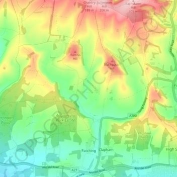
Name: Patching topographic map, elevation, terrain.

Location: Patching, Arun, West Sussex, England, United Kingdom (50.83693 -0.47755 50.89689 -0.44411)

Average elevation: 282 ft

Minimum elevation: 13 ft

Maximum elevation: 666 ft

Other topographic maps

Click on a map to view its topography, its elevation and its terrain.

Eastergate

United Kingdom > England > West Sussex > Arun

Average elevation: 39 ft

Barnham

United Kingdom > England > West Sussex > Arun

Average elevation: 20 ft

Fontwell

United Kingdom > England > West Sussex > Arun

Average elevation: 102 ft

Eastergate

United Kingdom > England > West Sussex > Arun

Average elevation: 39 ft

Shripney

United Kingdom > England > West Sussex > Arun

Average elevation: 10 ft

Wick

United Kingdom > England > West Sussex > Arun > Littlehampton > Lyminster

Average elevation: 10 ft

Middle Mead

United Kingdom > England > West Sussex > Arun > Littlehampton

Average elevation: 13 ft

Bognor Regis

United Kingdom > England > West Sussex > Arun > Nyetimber

Average elevation: 7 ft

Lidsey Rife

United Kingdom > England > West Sussex > Arun > Felpham

Average elevation: 10 ft

Elmer

United Kingdom > England > West Sussex > Arun

Average elevation: 7 ft

Nyetimber

United Kingdom > England > West Sussex > Arun

Average elevation: 10 ft

North Bersted

United Kingdom > England > West Sussex > Arun

Average elevation: 10 ft

Binsted

United Kingdom > England > West Sussex > Arun > Walberton

Average elevation: 75 ft

Gear up for your next adventure:

🧢Outdoor Hiking Hat - Sun protection hat for outdoor explorers
🥘Titanium Cookware - Durable, featherlight pots and pans for backpacking
🪵Folding Camp Saw - Compact saw for wood and campsite work
🧣Hiking Neck Gaiter - Multi‑use neck protection for outdoor weather
🏕️Tent Footprint - Protect your tent base from wear

As an Amazon Associate, this site earns from qualifying purchases at no extra cost to you.