Geolocate

Hatton topographic map

Click on the map to display elevation.

About this map

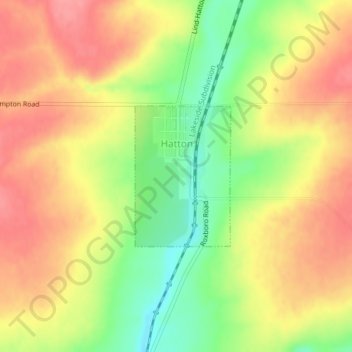
Name: Hatton topographic map, elevation, terrain.

Location: Hatton, Adams County, Washington, United States (46.76805 -118.83293 46.77887 -118.82222)

Average elevation: 1,181 ft

Minimum elevation: 1,024 ft

Maximum elevation: 1,296 ft

Adams County trails, hiking, mountain biking, running and outdoor activities

Other topographic maps

Click on a map to view its topography, its elevation and its terrain.

Benge

United States > Washington > Adams County

Average elevation: 1,572 ft

Gear up for your next adventure:

🪶LED Camping Lantern - Bright lantern for camp lighting
🧦Hiking Socks - Comfortable socks to prevent blisters on long hikes
🩳Quick‑Dry Hiking Shorts - Comfortable and quick‑dry shorts for summer hiking
🏥Hiking First Aid Kits - Comprehensive medical kits for remote trail injuries
🏫Relief Map Kits - Hands-on tools for teaching landforms and elevation

As an Amazon Associate, this site earns from qualifying purchases at no extra cost to you.