
Benge topographic map
Click on the map to display elevation.
About this map
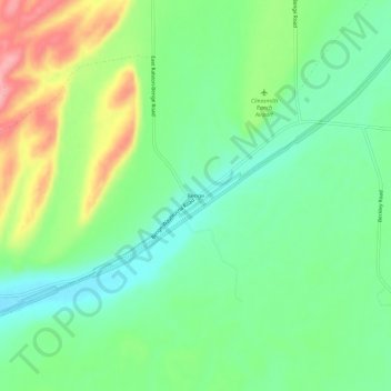
Name: Benge topographic map, elevation, terrain.
Location: Benge, Adams County, Washington, 99105, United States (46.88932 -118.12246 46.92932 -118.08246)
Average elevation: 1,572 ft
Minimum elevation: 1,427 ft
Maximum elevation: 1,831 ft
Adams County trails, hiking, mountain biking, running and outdoor activities
Other topographic maps
Click on a map to view its topography, its elevation and its terrain.
Washtucna
United States > Washington > Adams County
It sits at the head of Washtucna Coulee, a thin but deep valley that runs west to Connell, Washington where it merges with Providence Coulee to form Esquatzel Coulee. Being located on the floor of the coulee, Washtucna is at relatively lower elevation than the terrain that surrounds it. The floor of the coulee…
Average elevation: 1,152 ft