Geolocate

Elizabeth topographic map

Click on the map to display elevation.

About this map

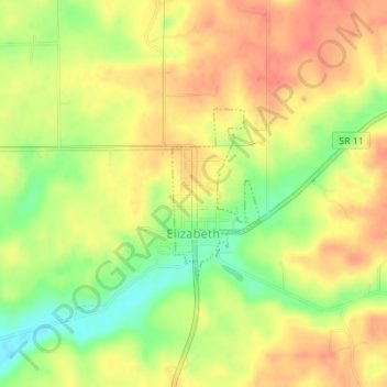
Name: Elizabeth topographic map, elevation, terrain.

Location: Elizabeth, Harrison County, Indiana, United States (38.11799 -85.97601 38.12990 -85.96819)

Average elevation: 774 ft

Minimum elevation: 669 ft

Maximum elevation: 843 ft

Harrison County trails, hiking, mountain biking, running and outdoor activities

Other topographic maps

Click on a map to view its topography, its elevation and its terrain.

Macedonia

United States > Indiana > Harrison County

Average elevation: 735 ft

Frenchtown

United States > Indiana > Harrison County

Average elevation: 758 ft

Hillcrest

United States > Indiana > Harrison County > Corydon

Average elevation: 656 ft

Gear up for your next adventure:

🛠️Backpacking Tool Kit - Essential toolkit for outdoor repairs
🕶️GPS Smartphone Mount - Secure mount for phone navigation
🥘Titanium Cookware - Durable, featherlight pots and pans for backpacking
📶Vehicle Signal Boosters - Improve reception in rural areas while driving to trailheads
💧Water Purification System - Clean water on the trail with reliable purifiers

As an Amazon Associate, this site earns from qualifying purchases at no extra cost to you.