
Make a donation
Gear up for your next adventure:
As an Amazon Associate, this site earns from qualifying purchases at no extra cost to you.
Turbenthal topographic map
Click on the map to display elevation.
Make a donation
Gear up for your next adventure:
As an Amazon Associate, this site earns from qualifying purchases at no extra cost to you.
About this map
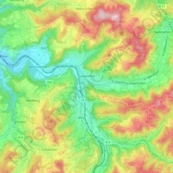
Name: Turbenthal topographic map, elevation, terrain.
Location: Turbenthal, Bezirk Winterthur, Zürich, 8488, Schweiz (47.40144 8.83006 47.46370 8.93309)
Average elevation: 2,188 ft
Minimum elevation: 1,686 ft
Maximum elevation: 2,881 ft
Make a donation
Gear up for your next adventure:
As an Amazon Associate, this site earns from qualifying purchases at no extra cost to you.
Other topographic maps
Click on a map to view its topography, its elevation and its terrain.
Schmidrüti
Schweiz > Zürich > Bezirk Winterthur > Turbenthal
Der Weiler liegt auf einer Höhe von 810 m ü. M. auf Zürcher Boden, direkt an der Grenze zum Kanton Thurgau. Schmidrüti liegt im Tösstal im Bezirk Winterthur und ist umgeben von der Gemeinde Turbenthal.
Average elevation: 2,444 ft
Make a donation
Gear up for your next adventure:
As an Amazon Associate, this site earns from qualifying purchases at no extra cost to you.
Gotzenwil
Schweiz > Zürich > Bezirk Winterthur > Winterthur
Gotzenwil ist eine Aussenwacht und zugleich ein Quartier der Stadt Winterthur und gehört zum Kreis 3 (Seen). Zur Aussenwacht gehört die Siedlung Weierhöhe und der Weiler Ziegelhütte.
Average elevation: 1,768 ft