Geolocate

Fremont topographic map

Click on the map to display elevation.

About this map

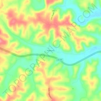
Name: Fremont topographic map, elevation, terrain.

Location: Fremont, Carter County, Missouri, 63941, United States (36.93227 -91.18430 36.97227 -91.14430)

Average elevation: 719 ft

Minimum elevation: 568 ft

Maximum elevation: 896 ft

Carter County trails, hiking, mountain biking, running and outdoor activities

Other topographic maps

Click on a map to view its topography, its elevation and its terrain.

Grandin

United States > Missouri > Carter County

Average elevation: 650 ft

Van Buren

United States > Missouri > Carter County

Average elevation: 561 ft

Ellsinore

United States > Missouri > Carter County

Average elevation: 768 ft

Gear up for your next adventure:

🗺️Topographic Maps - Detailed topo maps for hiking, exploring and outdoor navigation
🪶Camp Gear Gift Set - Perfect gift bundle for outdoor fans
🧥Waterproof Jacket for Hiking - Breathable and rugged rain jacket for outdoor excursions
🪶Multi‑Purpose Knife - Useful blade for camp and trail
📡GPS Antenna Upgrade - Enhance GPS reception in remote terrain

As an Amazon Associate, this site earns from qualifying purchases at no extra cost to you.