Geolocate

Watson topographic map

Click on the map to display elevation.

About this map

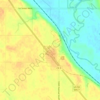
Name: Watson topographic map, elevation, terrain.

Location: Watson, Chippewa County, Minnesota, United States (45.00542 -95.80388 45.01607 -95.79567)

Average elevation: 1,001 ft

Minimum elevation: 938 ft

Maximum elevation: 1,050 ft

Chippewa County trails, hiking, mountain biking, running and outdoor activities

Other topographic maps

Click on a map to view its topography, its elevation and its terrain.

Asbury

United States > Minnesota > Chippewa County

Average elevation: 1,037 ft

Gear up for your next adventure:

🪶Camp Gear Gift Set - Perfect gift bundle for outdoor fans
🧯Portable Fire Pit - Compact fire pit for camping spots
🩹Survival Bandages - High‑quality bandages for emergencies
🔌USB Car Charger - Car charger for on‑the‑go power needs
🦟Ultrasonic Repellers - Create a bug-free zone at your camp or rest stop

As an Amazon Associate, this site earns from qualifying purchases at no extra cost to you.