Geolocate

Milton topographic map

Click on the map to display elevation.

About this map

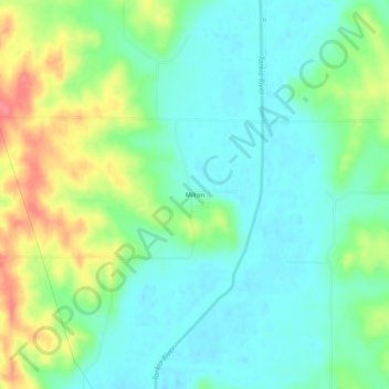
Name: Milton topographic map, elevation, terrain.

Location: Milton, Atchison County, Missouri, United States (40.26472 -95.43720 40.30472 -95.39720)

Average elevation: 945 ft

Minimum elevation: 866 ft

Maximum elevation: 1,115 ft

Atchison County trails, hiking, mountain biking, running and outdoor activities

Other topographic maps

Click on a map to view its topography, its elevation and its terrain.

Tarkio

United States > Missouri > Atchison County

Average elevation: 958 ft

Fairfax

United States > Missouri > Atchison County

Average elevation: 938 ft

Westboro

United States > Missouri > Atchison County

Average elevation: 1,033 ft

Watson

United States > Missouri > Atchison County

Average elevation: 902 ft

Nishnabotna

United States > Missouri > Atchison County

Average elevation: 961 ft

Gear up for your next adventure:

🧷Carabiner Set - Durable clips for gear attachment
🗺️Topographic Maps - Detailed topo maps for hiking, exploring and outdoor navigation
📷Action Camera - Capture your outdoor adventures in HD
🚪Portable Camp Chair - Foldable chair for comfort at camp
🔥Plasma Lighters - Windproof lighters that work in any weather condition

As an Amazon Associate, this site earns from qualifying purchases at no extra cost to you.