Geolocate

North Star topographic map

Click on the map to display elevation.

About this map

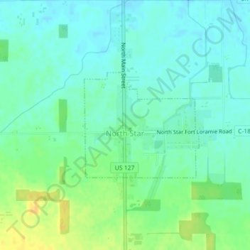
Name: North Star topographic map, elevation, terrain.

Location: North Star, Darke County, Ohio, United States (40.31961 -84.57670 40.33100 -84.56042)

Average elevation: 1,004 ft

Minimum elevation: 974 ft

Maximum elevation: 1,063 ft

Darke County trails, hiking, mountain biking, running and outdoor activities

Other topographic maps

Click on a map to view its topography, its elevation and its terrain.

Union Corners

United States > Ohio > Darke County

Average elevation: 1,010 ft

Webster

United States > Ohio > Darke County

Average elevation: 991 ft

Horatio

United States > Ohio > Darke County

Average elevation: 1,010 ft

Abbottsville

United States > Ohio > Darke County

Average elevation: 1,050 ft

Hill Grove

United States > Ohio > Darke County

Average elevation: 1,073 ft

Delisle

United States > Ohio > Darke County

Average elevation: 1,053 ft

Gear up for your next adventure:

💧Water Filtration Bottles - Safely drink from streams and lakes while exploring
🩹Survival Bandages - High‑quality bandages for emergencies
Camping Coffee Makers - Enjoy premium coffee at the summit or campsite
🛌Ultralight Sleeping Bags - Compact down bags for cold nights in the wilderness
🧯Emergency Survival Kit - All‑in‑one survival essentials for the backcountry

As an Amazon Associate, this site earns from qualifying purchases at no extra cost to you.