
Make a donation
Gear up for your next adventure:
As an Amazon Associate, this site earns from qualifying purchases at no extra cost to you.
Jyrgalan topographic map
Click on the map to display elevation.
Make a donation
Gear up for your next adventure:
As an Amazon Associate, this site earns from qualifying purchases at no extra cost to you.
About this map
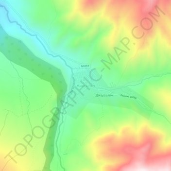
Name: Jyrgalan topographic map, elevation, terrain.
Average elevation: 7,864 ft
Minimum elevation: 7,005 ft
Maximum elevation: 9,160 ft
Make a donation
Gear up for your next adventure:
As an Amazon Associate, this site earns from qualifying purchases at no extra cost to you.
Other topographic maps
Click on a map to view its topography, its elevation and its terrain.
Ala-Köl
Kyrgyzstan > Issyk-Kul Region > Ak-Suu District
Ala-Köl (Kyrgyz: Ала-Көл, also Алакөл, Russian: Ала-Куль, romanized: Ala-Kul) is a rock-dammed lake in the Terskey Alatau mountain range in the Ak-Suu District of the Issyk-Kul Region in Kyrgyzstan. It lies at an altitude of 3,532 m (11,588 ft). It is 2.8 km (1.7 mi) long and 600–700 m…
Average elevation: 12,149 ft