
Make a donation
Gear up for your next adventure:
As an Amazon Associate, this site earns from qualifying purchases at no extra cost to you.
Crikvenica topographic map
Click on the map to display elevation.
Make a donation
Gear up for your next adventure:
As an Amazon Associate, this site earns from qualifying purchases at no extra cost to you.
About this map
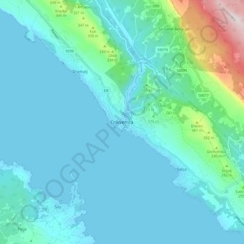
Name: Crikvenica topographic map, elevation, terrain.
Average elevation: 377 ft
Minimum elevation: -3 ft
Maximum elevation: 2,740 ft
Make a donation
Gear up for your next adventure:
As an Amazon Associate, this site earns from qualifying purchases at no extra cost to you.
Other topographic maps
Click on a map to view its topography, its elevation and its terrain.
Susak
Croatia > Primorje-Gorski Kotar County > Susak
Located in the Kvarner Bay and southeast of the Istrian peninsula, the Croatian island of Susak is 7.4 kilometers (4.6 mi; 4.0 nmi) southwest from the island of Lošinj, 10 kilometers (6.2 mi; 5.4 nmi) south of the island of Unije, and 120 kilometers (75 mi; 65 nmi) east of the Italian coast. Susak is about 3…
Average elevation: 43 ft
Make a donation
Gear up for your next adventure:
As an Amazon Associate, this site earns from qualifying purchases at no extra cost to you.