
Make a donation
Gear up for your next adventure:
As an Amazon Associate, this site earns from qualifying purchases at no extra cost to you.
Centerville topographic map
Click on the map to display elevation.
Make a donation
Gear up for your next adventure:
As an Amazon Associate, this site earns from qualifying purchases at no extra cost to you.
Centerville
Centerville Borough is located just north of the southern terminal moraine for glaciation in northwestern Pennsylvania. The borough is drained by Oil Creek, a southward-flowing tributary of the Allegheny River, which runs through the western side of town and East Branch Oil Creek, which enters the borough from the northeast and joins the main creek west of the borough center. The lowest elevation in Centerville is 1,260 ft (380 m), where Oil Creek flows south from the borough. The highest elevation is 1,510 ft (460 m) at the northern borough boundary.
Make a donation
Gear up for your next adventure:
As an Amazon Associate, this site earns from qualifying purchases at no extra cost to you.
About this map
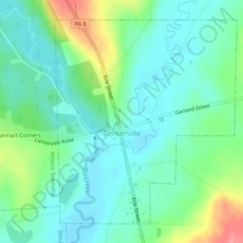
Name: Centerville topographic map, elevation, terrain.
Location: Centerville, Crawford County, Pennsylvania, United States (41.72605 -79.77310 41.74876 -79.74595)
Average elevation: 1,342 ft
Minimum elevation: 1,260 ft
Maximum elevation: 1,552 ft
Crawford County trails, hiking, mountain biking, running and outdoor activities
Make a donation
Gear up for your next adventure:
As an Amazon Associate, this site earns from qualifying purchases at no extra cost to you.
Other topographic maps
Click on a map to view its topography, its elevation and its terrain.
Espyville
United States > Pennsylvania > Crawford County > Pymatuning Central
Average elevation: 1,047 ft