
Bouhajla topographic map
Interactive map
Click on the map to display elevation.
About this map
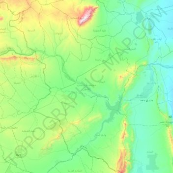
Name: Bouhajla topographic map, elevation, terrain.
Location: Bouhajla, Kairouan, Tunisie (35.23074 9.39485 35.60280 9.72817)
Average elevation: 1,145 ft
Minimum elevation: 505 ft
Maximum elevation: 3,255 ft
Other topographic maps
Click on a map to view its topography, its elevation and its terrain.
Hajeb El Ayoun
Tunisie > Kairouan > Hajeb El Ayoun
Hajeb El Ayoun, El Hajeb Centre, Bouhajla, Kairouan, Tunisie
Average elevation: 1,106 ft
Oued Zeroud
Oued Zeroud, Abida, Echebika, Kairouan, 3151, Tunisie
Average elevation: 331 ft
El Ain El Beidha
El Ain El Beidha, Haffouz, Kairouan, Tunisie
Average elevation: 938 ft
Oued El Jabbes
Oued El Jabbes, Haffouz, Kairouan, Tunisie
Average elevation: 1,188 ft