
Make a donation
Gear up for your next adventure:
As an Amazon Associate, this site earns from qualifying purchases at no extra cost to you.
Orfordville topographic map
Click on the map to display elevation.
Make a donation
Gear up for your next adventure:
As an Amazon Associate, this site earns from qualifying purchases at no extra cost to you.
Orfordville
Orfordville is located at 42°37′45″N 89°15′24″W / 42.62917°N 89.25667°W / 42.62917; -89.25667 (42.629300, −89.256755). The elevation is 889 feet (271 m).
Make a donation
Gear up for your next adventure:
As an Amazon Associate, this site earns from qualifying purchases at no extra cost to you.
About this map
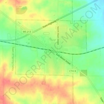
Name: Orfordville topographic map, elevation, terrain.
Location: Orfordville, Rock County, Wisconsin, 53576, United States (42.61940 -89.26868 42.63618 -89.24351)
Average elevation: 915 ft
Minimum elevation: 814 ft
Maximum elevation: 1,014 ft
Rock County trails, hiking, mountain biking, running and outdoor activities
Make a donation
Gear up for your next adventure:
As an Amazon Associate, this site earns from qualifying purchases at no extra cost to you.
Other topographic maps
Click on a map to view its topography, its elevation and its terrain.
Johnstown Center
United States > Wisconsin > Rock County > Town of Johnstown
Average elevation: 951 ft
Make a donation
Gear up for your next adventure:
As an Amazon Associate, this site earns from qualifying purchases at no extra cost to you.