Geolocate

Pomona topographic map

Click on the map to display elevation.

About this map

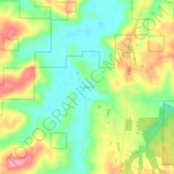
Name: Pomona topographic map, elevation, terrain.

Location: Pomona, Jackson County, Illinois, 62975, United States (37.60811 -89.35676 37.64811 -89.31676)

Average elevation: 531 ft

Minimum elevation: 374 ft

Maximum elevation: 741 ft

Jackson County trails, hiking, mountain biking, running and outdoor activities

Other topographic maps

Click on a map to view its topography, its elevation and its terrain.

Grand Tower

United States > Illinois > Jackson County

Average elevation: 364 ft

Dowell

United States > Illinois > Jackson County

Average elevation: 404 ft

De Soto

United States > Illinois > Jackson County

Average elevation: 394 ft

Gear up for your next adventure:

🪄Magnetic Compass - Accurate compass for navigation
🏕️Tent Footprint - Protect your tent base from wear
🎒Outdoor Daypacks - Lightweight backpacks designed for carrying maps and essential gear
🚁Photography Drones - Capture stunning aerial views of landforms and topography
🥾Men's Hiking Boots - Durable, waterproof footwear for rugged terrain and steep inclines

As an Amazon Associate, this site earns from qualifying purchases at no extra cost to you.