Geolocate

Bryncrug topographic map

Click on the map to display elevation.

About this map

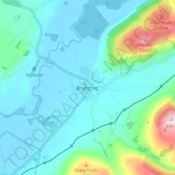
Name: Bryncrug topographic map, elevation, terrain.

Location: Bryncrug, Gwynedd, Wales, LL36 9PB, United Kingdom (52.58800 -4.07500 52.62800 -4.03500)

Average elevation: 200 ft

Minimum elevation: -7 ft

Maximum elevation: 1,106 ft

Other topographic maps

Click on a map to view its topography, its elevation and its terrain.

Llyn y Dywarchen

United Kingdom > Wales > Gwynedd > Rhyd-ddu

Average elevation: 856 ft

Betws Garmon

United Kingdom > Wales > Gwynedd

Average elevation: 935 ft

Llyn Cau

United Kingdom > Wales > Gwynedd

Average elevation: 1,821 ft

Gear up for your next adventure:

🧭Pro Hiking Compasses - High-accuracy liquid-filled compasses for topographic orientation
🏕️Tent Footprint - Protect your tent base from wear
🛰️Satellite Messengers - Emergency SOS and two-way messaging for off-grid adventures
🪵Folding Camp Saw - Compact saw for wood and campsite work
🩳Quick‑Dry Hiking Shorts - Comfortable and quick‑dry shorts for summer hiking

As an Amazon Associate, this site earns from qualifying purchases at no extra cost to you.