Geolocate

Jefferson topographic map

Click on the map to display elevation.

About this map

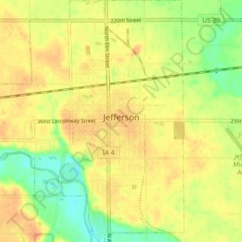
Name: Jefferson topographic map, elevation, terrain.

Location: Jefferson, Greene County, Iowa, 50129, United States (41.99184 -94.41647 42.03839 -94.35782)

Average elevation: 1,047 ft

Minimum elevation: 968 ft

Maximum elevation: 1,096 ft

Greene County trails, hiking, mountain biking, running and outdoor activities

Other topographic maps

Click on a map to view its topography, its elevation and its terrain.

Cooper

United States > Iowa > Greene County

Average elevation: 1,066 ft

Gear up for your next adventure:

🧭Hiking Compass - Precision compass for reliable navigation in the wilderness
🛡️Insect Repellent - Protection against bugs during outdoor activities
🔋Rechargeable Batteries - Power up your outdoor devices
📷Action Cameras - Rugged cameras to document your journeys across rugged terrain
🛡️Bear Spray Outdoor - Protection in bear country hikes

As an Amazon Associate, this site earns from qualifying purchases at no extra cost to you.