
Make a donation
Gear up for your next adventure:
As an Amazon Associate, this site earns from qualifying purchases at no extra cost to you.
Feusdorf topographic map
Click on the map to display elevation.
Make a donation
Gear up for your next adventure:
As an Amazon Associate, this site earns from qualifying purchases at no extra cost to you.
Feusdorf
Feusdorf's area is 442 ha all together, of which cropfields and open water make up 78 ha, greenbelt and heath 203 ha, private property 26 ha, woods 105 ha, public roadways 26 ha and other lands 4 ha. Flurbereinigung was undertaken in 1968. Feusdorf lies at an elevation of 450 to 565 m above sea level.
Make a donation
Gear up for your next adventure:
As an Amazon Associate, this site earns from qualifying purchases at no extra cost to you.
About this map
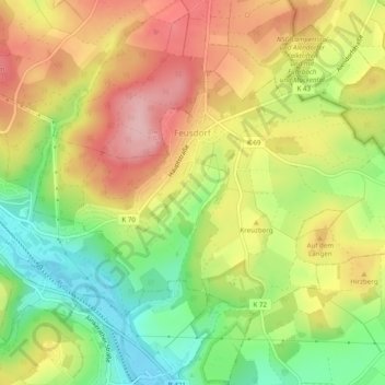
Name: Feusdorf topographic map, elevation, terrain.
Average elevation: 1,650 ft
Minimum elevation: 1,371 ft
Maximum elevation: 1,916 ft
Make a donation
Gear up for your next adventure:
As an Amazon Associate, this site earns from qualifying purchases at no extra cost to you.
Other topographic maps
Click on a map to view its topography, its elevation and its terrain.
Hinterhausen
Germany > Rhineland-Palatinate > Landkreis Vulkaneifel > Gerolstein
Average elevation: 1,493 ft
Make a donation
Gear up for your next adventure:
As an Amazon Associate, this site earns from qualifying purchases at no extra cost to you.