
Tabernas topographic map
Click on the map to display elevation.
About this map
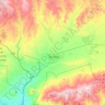
Name: Tabernas topographic map, elevation, terrain.
Location: Tabernas, Almeria, Andalusia, 04200, Spain (36.98557 -2.48896 37.15400 -2.22585)
Average elevation: 2,198 ft
Minimum elevation: 522 ft
Maximum elevation: 4,514 ft
Other topographic maps
Click on a map to view its topography, its elevation and its terrain.
Granada
Spain > Andalusia > Granada > Granada
Granada (/ɡrəˈnɑːdə/ grə-NAH-də, Spanish: , locally ) is the capital city of the province of Granada, in the autonomous community of Andalusia, Spain. Granada is located at the foot of the Sierra Nevada mountains, at the confluence of four rivers, the Darro, the Genil, the Monachil and the Beiro.…
Average elevation: 3,422 ft
Sierra Nevada
Spain > Andalusia > Comarca de Guadix
Parts of the range have been included in the Sierra Nevada National Park. The range has also been declared a biosphere reserve. The Sierra Nevada Observatory, the Calar Alto Observatory, and the IRAM 30m telescope are located on the northern slopes at an elevation of 2,800 metres (9,200 ft).
Average elevation: 4,298 ft
Santa Margarita
Spain > Andalusia > Campo de Gibraltar > La Línea de la Concepción
Average elevation: 207 ft
Sierra Nevada
Spain > Andalusia > Comarca de la Alpujarra Granadina > Lanjarón
Average elevation: 7,293 ft
Río de la Toba
Spain > Andalusia > Comarca de la Costa Granadina > Los Guájares
Average elevation: 1,037 ft