
Reedsburg topographic map
Click on the map to display elevation.
About this map
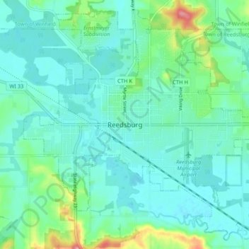
Name: Reedsburg topographic map, elevation, terrain.
Location: Reedsburg, Sauk County, Wisconsin, United States (43.50531 -90.03562 43.55953 -89.95470)
Average elevation: 922 ft
Minimum elevation: 856 ft
Maximum elevation: 1,178 ft
Sauk County trails, hiking, mountain biking, running and outdoor activities
Other topographic maps
Click on a map to view its topography, its elevation and its terrain.
Parfrey's Glen State Natural Area
United States > Wisconsin > Sauk County > Town of Merrimac
Average elevation: 1,181 ft