
Diets-Heur topographic map
Click on the map to display elevation.
Diets-Heur
Diets-Heur bevindt zich in droog-Haspengouw op een hoogte van 97 tot 137 meter. De enige waterloop is het beekje de Buth, dat in noordoostelijke richting stroomt. Het dorp ligt aan de taalgrens.
About this map
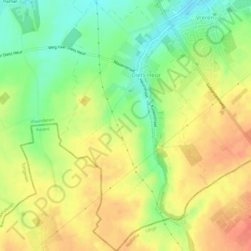
Name: Diets-Heur topographic map, elevation, terrain.
Location: Diets-Heur, Tongeren, Limburg, Vlaanderen, België (50.72353 5.46748 50.75412 5.49637)
Average elevation: 407 ft
Minimum elevation: 308 ft
Maximum elevation: 499 ft
Other topographic maps
Click on a map to view its topography, its elevation and its terrain.
Offelken
België > Limburg > Tongeren > Tongeren
Offelken ligt in Droog-Haspengouw. De hoogte varieert tussen 88 en 98 meter. De kern van het gehucht ligt ten zuiden van de aftakking van de Oude Jeker. Deze waterloop werd aangelegd door de mens en heeft een lengte van ongeveer drie kilometer.
Average elevation: 315 ft