
Damer Lake topographic map
Click on the map to display elevation.
About this map
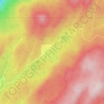
Name: Damer Lake topographic map, elevation, terrain.
Average elevation: 4,439 ft
Minimum elevation: 3,612 ft
Maximum elevation: 4,833 ft
Other topographic maps
Click on a map to view its topography, its elevation and its terrain.
Hydraulic Lake
Canada > British Columbia > Regional District of Central Okanagan > East Central Okanagan Electoral Area
Average elevation: 4,154 ft
Oyama Lake
Canada > British Columbia > Regional District of Central Okanagan > East Central Okanagan Electoral Area
Average elevation: 4,551 ft
Little White Mountain
Canada > British Columbia > Regional District of Central Okanagan > East Central Okanagan Electoral Area
Average elevation: 6,348 ft
Crooked Lake
Canada > British Columbia > Regional District of Central Okanagan > East Central Okanagan Electoral Area
Average elevation: 4,524 ft
Swalwell Lake
Canada > British Columbia > Regional District of Central Okanagan > East Central Okanagan Electoral Area
Average elevation: 4,537 ft
Black Knight Mountain
Canada > British Columbia > Regional District of Central Okanagan > East Central Okanagan Electoral Area
Average elevation: 3,255 ft
Oyama Lake
Canada > British Columbia > Regional District of Central Okanagan > East Central Okanagan Electoral Area
Average elevation: 4,551 ft