
Make a donation
Gear up for your next adventure:
As an Amazon Associate, this site earns from qualifying purchases at no extra cost to you.
Stari Mikanovci topographic map
Click on the map to display elevation.
Make a donation
Gear up for your next adventure:
As an Amazon Associate, this site earns from qualifying purchases at no extra cost to you.
About this map
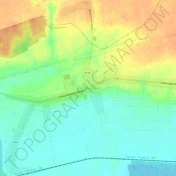
Name: Stari Mikanovci topographic map, elevation, terrain.
Average elevation: 315 ft
Minimum elevation: 249 ft
Maximum elevation: 397 ft
Make a donation
Gear up for your next adventure:
As an Amazon Associate, this site earns from qualifying purchases at no extra cost to you.
Other topographic maps
Click on a map to view its topography, its elevation and its terrain.
Vinkovci
Croatia > Vukovar-Srijem County
Vinkovci is located in the eastern part of the Slavonia region, 19 km (12 mi) southwest of Vukovar, 24 km (15 mi) north of Županja and 43 km (27 mi) south of Osijek. The city lies in a flatland on the Bosut river, at an elevation of approx. 90 metres (300 ft), and has a mild continental climate. Vinkovci is…
Average elevation: 289 ft
Make a donation
Gear up for your next adventure:
As an Amazon Associate, this site earns from qualifying purchases at no extra cost to you.
Vukovar
Croatia > Vukovar-Srijem County
Vukovar is located 20 km (12 mi) northeast of Vinkovci and 36 km (22 mi) southeast of Osijek, with an elevation of 108 m (354 ft). Vukovar is located on the main road D2 Osijek—Vukovar—Ilok and on the Vinkovci—Vukovar railway (and road D55).
Average elevation: 308 ft