
Village of Germantown topographic map
Interactive map
Click on the map to display elevation.
About this map
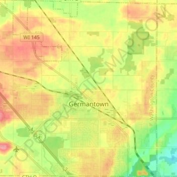
Name: Village of Germantown topographic map, elevation, terrain.
Average elevation: 876 ft
Minimum elevation: 732 ft
Maximum elevation: 1,014 ft
Other topographic maps
Click on a map to view its topography, its elevation and its terrain.
West Bend
United States > Wisconsin > Washington County
West Bend, Washington County, Wisconsin, United States
Average elevation: 978 ft
Town of Addison
United States > Wisconsin > Washington County
Town of Addison, Washington County, Wisconsin, 53002, United States
Average elevation: 1,043 ft
Town of Polk
United States > Wisconsin > Washington County
Town of Polk, Washington County, Wisconsin, 53086, United States
Average elevation: 1,001 ft
Slinger
United States > Wisconsin > Washington County
Slinger, Washington County, Wisconsin, United States
Average elevation: 1,086 ft
Hartford
United States > Wisconsin > Washington County
Hartford, Washington County, Wisconsin, 53027, United States
Average elevation: 1,027 ft
Village of Richfield
United States > Wisconsin > Washington County
Village of Richfield, Washington County, Wisconsin, United States
Average elevation: 971 ft
Allenton
United States > Wisconsin > Washington County > Allenton
Allenton, Washington County, Wisconsin, 53002-9800, United States
Average elevation: 1,027 ft
Kewaskum
United States > Wisconsin > Washington County
Kewaskum, Washington County, Wisconsin, United States
Average elevation: 968 ft