
Make a donation
Gear up for your next adventure:
As an Amazon Associate, this site earns from qualifying purchases at no extra cost to you.
Saint Maries topographic map
Click on the map to display elevation.
Make a donation
Gear up for your next adventure:
As an Amazon Associate, this site earns from qualifying purchases at no extra cost to you.
About this map
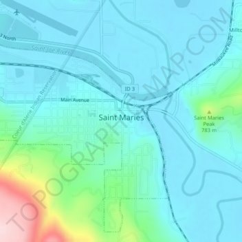
Name: Saint Maries topographic map, elevation, terrain.
Location: Saint Maries, Benewah County, Idaho, United States (47.30156 -116.59179 47.32622 -116.55449)
Average elevation: 2,260 ft
Minimum elevation: 2,106 ft
Maximum elevation: 3,041 ft
Benewah County trails, hiking, mountain biking, running and outdoor activities
Make a donation
Gear up for your next adventure:
As an Amazon Associate, this site earns from qualifying purchases at no extra cost to you.
Other topographic maps
Click on a map to view its topography, its elevation and its terrain.
De Smet
United States > Idaho > Benewah County
U.S. Route 95 passes nearby and the community is located about a mile (1.6 km) south of Tensed, which was originally also to be titled Desmet before the name was ordered to be reversed and was subsequently misspelled by the post office. Latah Creek flows between the two communities. De Smet has a post office…
Average elevation: 2,605 ft