Geolocate

Cashion topographic map

Click on the map to display elevation.

About this map

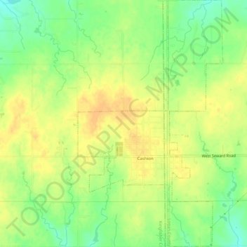
Name: Cashion topographic map, elevation, terrain.

Location: Cashion, Kingfisher County, Oklahoma, 73016, United States (35.78390 -97.69206 35.82351 -97.66335)

Average elevation: 1,112 ft

Minimum elevation: 1,050 ft

Maximum elevation: 1,152 ft

Kingfisher County trails, hiking, mountain biking, running and outdoor activities

Other topographic maps

Click on a map to view its topography, its elevation and its terrain.

Omega

United States > Oklahoma > Kingfisher County

Average elevation: 1,204 ft

Gear up for your next adventure:

🪶Survival Guide Book - Expert advice for emergency preparedness
🔋Rechargeable Batteries - Power up your outdoor devices
👖Convertible Hiking Pants - Versatile zip-off pants for changing altitudes and temperatures
📖Nature Tracking Books - Learn to track wildlife and terrain
🪶LED Camping Lantern - Bright lantern for camp lighting

As an Amazon Associate, this site earns from qualifying purchases at no extra cost to you.